| Andes Archaeogeodesy Pages |
|
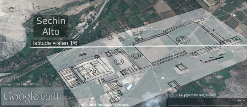
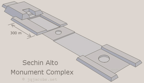
2017-10-21 - International Archaeology Day - Now online, an updated Casma-Sechin Archaeogeodesy KML file, sechin.kml. Global, Andean, and intra-valley site relationship findings are featured. This page is the companion website. The file may seem esoteric to those not already familiar with my previous writing and placemark files. The following discussion is intended to help overcome that obstacle and to present some of the results in a more widely accessible format. Perhaps this will encourage more archaeologists and students alike to explore Google Earth as an archaeology tool. In February, I reviewed and refined coordinates for Casma-Sechin monuments following a Google Earth hi-res update. With refined coordinates, I started analysis of monument inter-relationship geomertry. The large scale of the monument distribution in the Casma and Sechin valleys provides a set of monuments useful for intra-site study. Additionally, not only is the latitude of the Sechin complex significant (graphic below), radiocarbon dating at Sechin Bajo predates the pyramids at Giza.
The Casma-Sechin intra-site geometry analysis was prompted in part by results of study of the Monumental Mounds complex and immense circular earthworks in the Bolivian Amazon (bolivia.kml). Those results include Nevado Huascaran and Sechin. I sought another region to reapply intra-site geomertry analysis after encouraging results from analysis of the Bolivia sites. The Bolivia analysis relied on a GPS survey of lomas by Umberto Lombardo and on my own survey of visible zanjas in Google Earth. The Casma-Sechin stone monument details are readily visible in Google Earth, whereas the Bolivian lomas are eroded earthen mounds often obscured by vegetation, making coordinate verification more difficult and less precise without GPS. I wanted to repeat the study in an area better suited to Google Earth methodolgy. The recent high resolution satellite imagery and scale of monument spacing at Casma-Sechin offered appropriate data for some of the most important early monuments in the Americas. |
|
The image above illustrates several points and the shorthand used in the balloons. The illustrated placemark is named secal-cargp, the label visible in Google Earth's Places menu. These two site name codes represent Sechin Alto and Caral Greater Pyramid. The placemark includes a line tessellated between sites to visually represent the site-to-site relationship. Of course, this does not represent an actual line on the ground nor is their any intention to imply any correlated constructs. The purpose of the line is representational and utilitarian, allowing display of all site relationships and clicking on the lines to read the recorded data. Enter the site codes in the archaeogeodesy.xls applet (range F5-F7, illustrated below) and the applet uses the latitude and longitude coordinates they represent to calculate arc distances, bearings, and other results. In the code worksheet, partially formed KML can be copied to create the corresponding file by completing the coding and saving the text file as a .kml. In the image above, the placemark balloon displays the relationship Sechin Alto - Caral Greater Pyramid. The line presenting the ratio "n-s : e-w @ cargp = 1.0 : 0.500004" indicates the north-south distance between the monuments is twice the east-west distance at Caral. In the placemarks balloons in parentheses I present the margin of error in meters. Using e-w @ indicates ground measure, which varies with latitude for the same number of degrees of longitude. Contrastingly, my shorthand e-w° indicates actual degrees. Site codes such as secal-cargp can be resolved using the archaeogeodesy.xls applet by entering them in the arcs worksheet, range F5-F7, illustrated below. The sites worksheet listing all the sites and corresponding variables can be sort ordered alphabetically using the range name "sitelist." The current Excel applet and archaeogeodesy.kml file contain about 7,800 monument coordinates globally. In Google Earth, clicking the five letter coded site placemarks on the satellite imagery displays balloons with site names, coordinates, any other information, and photo embeds. Download my global KML placemarks file to display all sites. The sechim.kml file only presents sites in the Casma-Sechin area.
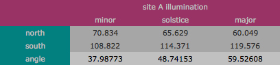
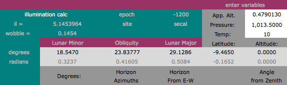
The module codes seen in displayed results are defined in the epoch worksheet of the applet. The modules and fundamental astronomy are discussed in Eclipses, Cosmic Clockwork of the Ancients. The first eight are astronomical motion units equating time and space. The astronomical values adjust according to the selected epoch setting, arcs worksheet, cell F17. Most results displayed in this KML file are epoch chavin, -1200 as displayed in cell E17. The temporal calculator, Epoch Calc, is embedded in the epoch worksheet.
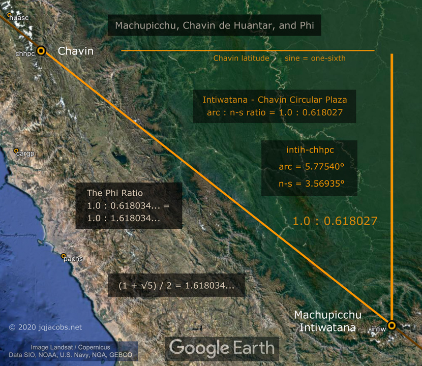
The following image displays an arc distances ratio from Marcahuamachuco to the immense Sechin Alto and Pachacamac huacas. The ratio reflects one of the fundamental astronomical constants, albeit the decimal is shifted. Lunar orbit per rotation is also one of the modules; r27 equals 0.036501 circumference. For the geodetic placements to precisely represent 1.0 : 10 lr (lunar orbit per rotation), the lesser arc would be one meter shorter (+1m). The method of determining monument coordinates is not that precise. Distant inter-site scale is far greater than intra-valley relationships, hence several meters difference has far less impact on the numerical precision of the ratios. Greater scale of monuument spacing enables higher precision of numerical expression and accuracy of representation. Perhaps the decimal shift seen in this and other examples functions to be able to represent the astronomy constants with greater accuracy. Of course, over even greater, global distances variable tectonic motion is a factor, moreso the more ancient the monuments. While not included in this file, I have calculated the temporal change in monument coordinates and distant spatial relationships using individual site tectonic motion modeling.
The method of determining the monument centerpoint coordinates is not as precise as these Marcahuamachuco results. Several meters of plus/minus inaccuracy must be assumed for all site coordinates given the methodology used. Distant inter-site scale is far greater than intra-valley relationships, hence several meters difference has far less impact on the numerical precision of their ratios. Greater scale of monuument spacing enables greater accuracy in relationship results and higher precision in correlated numerical expression. This is a reason I favor researching long distance relationships; the small error can be a mere one-millionth of the arc distance between sites. Perhaps the decimal shift seen in the Marcahuamachuco and other examples is functional, enabling representing the astronomy constants with greater accuracy. Of course, over even greater, global distances variable tectonic motion is a factor, moreso the more ancient the monuments. While not included in this file, I have calculated the temporal change in monument coordinates and distant spatial relationships using individual site tectonic motion modeling. Some of those coordinates are found in the applet. Results presented should be considered in the context of previous results available online and linked in the placemarks and below. Additional research results for other monument complexes remain unpublished. More findings are available to professionals employing the applet and data to examine site relationships for themselves. Chavin de Huantar Archaeogeodesy — Chavin de Huantar KML file. |


|
There is no user manual. Unlock worksheet protection with the password "arc". Cells to input or select variables and data have a white background. The applet allows the user to set the epoch. The drop menu in the arcs worksheet, cell F17 has preset epochs and a user drop-menu selection. Epoch chavin is selected in the graphic below. Each epoch's corresponding year, month, and day are entered in the epoch worksheet, range B150-E184. The user can specify more epochs in the blank lines there. The "user" selection in the drop menu employs the year, month, and day variables entered in range I16-I18 of the arcs worksheet. Note also the corresponding Julian Day number (JD) next to the epoch selector.
The epoch setting alters the illumination results moreso than astronomy constants. Illumination angles are quite variable from day to day and over time, so I rarely take note of them. Therefore, my illumination calculator is not a very refined formulation. Atmospheric variables are input in the calc worksheet, range L75-L77, where you can also access the formulation.
Site-to-site bearings are displayed in range E13-F15. Only rarely do three sites form a great circle line (ley lines in pseudoscience writing). I use the arcs worksheet, range C43-J52 as a scratch board to do math and other temporary tasks. Cells D40-J42 are used to determine degrees difference and convert differences to meters. Both "user" and "user2" are site variables used without adding a site to the database, respectively for adjusting the coordinates of an existing site variable (G10-H10) and for entering user coordinates (C18-D18). I use an iMac with 2560 x 1435 display, allowing display of three worksheets at one. This 2.8 MB screen capture image illustrates my current work environment. Contact me if you have any questions. I am willing to consult with professionals and to share other research results with qualifying persons and institutions. |

|
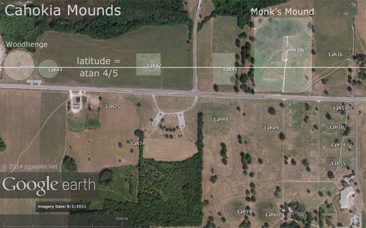
The importance of the Sechin complex is not just evident by the massiveness of Sechin Alto, the age of Sechin Bajo, or the incredible number of carved megaliths at the Cerro Sechin huaca, but also by the latitude trigonometry. Before ancient Egyptians erected pyramids and Europeans erected the great stone circles, an ancient Andean culture placed a monument at the latitude forming a 1 : 6 sided triangle in relation to the center of the earth. Additionally, important major monuments in the Andes and on the other continents were erected with apparent relationships to the earlier Sechin complex. In the 1980s I noted the geodetic geometry of Cahokia. Cahokia's obvious east-west axis, Woodhenge, and Monks Mound, the largest prehistoric monument north of Mexico and the largest-in-volume prehistoric earthen construction in the Americas, are situated in relation to the geodetic latitude. Specifically, the latitude tangent equals precisely 0.80, four-fifths. In other words the site's geodetic axis, the line to the center of the earth's mass, is the hypotenuse of a 4:5 geocentric triangle.
Thereafter I determined and converted the latitudes of other major monuments to trigonometric functions and other geodetic and astronomical modules. One of the oldest known stone circles is Nabta Playa in Egypt. The latitude placement of Nabta Playa, near one-fourth the distance from equator to pole, could imply intentional latitude placement originates by around 7,500 years ago. Given such early context, less suprisingly some of the largest monuments in the world and earliest major monuments in both hemispheres evidence construction at specific significant latitudes, latitudes which imply accurate astronomy, systematic point positioning, and possibly observational astronomy as a function of their geodetic positions. The geometry of the angle between the local geodetic and celestial reference frames presents a functional rationale to place astronomical observatories at locations with low-integer geodetic triangles. Monument placement at latitudes where small rational numbers describe the local geometric relationship to celestial motions has astronomical utility. Such placement of observations provides considerable simplification of mathematical operations. With simple integer ratios expressing trigonometric functions, complex math operations are easier while also eliminating the inaccuracy of decimal rounding. Given latitude placements are intentional, monument positioning evidences the earliest known precise astronomical and geodetic measurements. Thus, great ancient monuments evidence a capability of accurately determining latitude spanning the range of their construction. The earliest evidence of astronomical observatories using exact sciences is implied by monument latitude positioning. Astronomy is essential to place determination relative to the whole earth. Latitude is far easier to determine than is longitude. Geodetic latitude is determined using earth's poles and the celestial poles, extensions of the earth's axis of rotation to two fixed, non-moving points in space. To determine geodetic latitude the local level and plumb reference frame is compared with the angular position of an astronomical pole. The poles inter-reference astronomical and terrestrial coordinates. At Cahokia, the North Pole angle's tangent is five-fourths. While trigonometric function was a new consideration which I first brought to ancient monument placements, another latitude property, fractional geodivisions of circumference had received previous notice. Livio Stecchini noted the latitude at Karnak equals one-seventh the meridian arc and wrote that ancient geographers divided the meridian from equator to pole into seven zones. The latitude baseline equaling one-fourteenth of earth's circumference intersects Karnak, passing between the Mut and Amun Halls. By comparison, the list of Nile monuments closest to similar geometric subdivisions presents large margins of error. The Giza pyramids are several kilometers from one-twelfth of circumference (30.0°), a significant error. Without precision, intentionality is not a valid consideration. Tectonic shift needs to be incorporated in accuracy considerations. Precise latitude and the accuracy of placement of monuments is only recently relatively easy to determine. In 1984, the World Geodetic System (WGS) established accurate global place determination and point positioning in a universal geodetic reference frame. Current cartography research and study also benefits from recently developed tools and methods. The Google Earth virtual globe has placed high resolution aerial and satellite imagery at anyone's fingertips, along with the capability to create customized placemark files and some of the graphics herein. And, of course, accurate GPS devices employing the global positioning system pinpoint user positions. With the aid of modern technology we have caught up to ancient geodetic science sufficiently to realize the geometry and placements of ancient monuments is complex rather than unordered. |
|
Hundreds of Geoglifos Discovered in the Amazon
|

© 2024 by James Q. Jacobs. All Rights Reserved.
"Antiquity willfully veils the truth so that the fool will go astray and only the wise may know."
Phaedrus, writer of fables, writing in Rome.