|
Temporal
Illumination
Changes
By simply comparing alignments
and past
illumination geometry, temporal illumination
changes can be employed
both to test claims in literature and as
date-reaching mechanisms.
Proposed intentional solar and lunar alignments
can only be assessed
for accuracy after first determining equivalent
angles during the
construction/use epoch. Reconsidered in this
light, many published
claims for alignments may not pass critical
scrutiny. Past authors may
not have considered temporal variables.
Alignment claims in literature
require critical reassessment in temporal terms
before acceptance, in
particular, for authors who make no mention of
temporal changes.
Photographs of sunrise over the Heel Stone at
Stonehenge epitomize this
problem and convey a false impression of static
illumination angles
over time.
Geometry in the landscape can be
determined, measured, and analyzed objectively,
and with extreme
accuracy, especially when your 360° scale
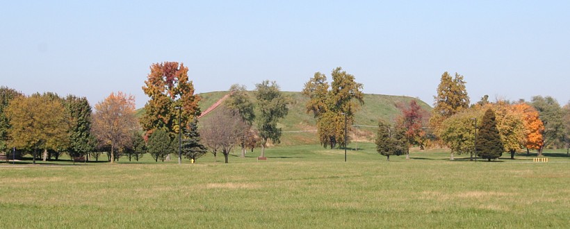
encircles a planet. For
example, not far from 14-acre, 100-foot-high Monks
Mound—the
largest-in-volume prehistoric earthen mound in
the Americas—the
solstice horizon angle and solstice rise/set
azimuths from the poles
approximate one-sixth of circumference (CIR/6).
I read that Monks
Mound's placement may have been intentional due
to the 60° solstice
angle at the site, so I investigated.
The latitude where the solstice
angle and
azimuths equal 60° changes over time. During
Monks Mound's
occupation span, the 60° solstice latitude
was nearly thirty miles
south of where it is today. Even today, it is
still south of Monks
Mound. Monks Mound and the 60° solstice
angle will only coincide
briefly as that node passes through Monks Mound.
With this finding, I
questioned the claim and the builder's
hypothetical intentions.
|
 Monks
Mound Terrace 4 Center Point
38.660750N 90.0620417W GPS Monks
Mound Terrace 4 Center Point
38.660750N 90.0620417W GPS
|
Meanwhile, my equations
revealed that
today the Monks Mound's latitude tangent is
0.80002. Latitude, like
obliquity, varies with time. Using secular polar
motion as a
date-reaching mechanism, I determined the
latitude tangent at Monks
Mound equaled precisely 0.80 in 1200 A.D. This
is in close agreement
with radiocarbon dating of final constructions
atop the mound. (The
secular polar motion shift formula is in the Astronomy
Formulas page. GPS readings are in the Cahokia Photo
Gallery.)
This relatively static property
of
latitude seems a more plausible reason for the
placement of Monks Mound
than the temporably variable solstice rise/set
angle. Illumination
geometry changes dramatically over time compared
to latitude values. In
cultures with a long tradition of mound
building, knowledge of this
temporal change is to be expected within the
hypothetical framework
postulating such intentional alignments. After
all, change in obliquity
dramatically impacts local illumination angles
during the temporal
sequences represented at archaeological remains.
Stonehenge,
Heel
Stone,
Solstice, and Sections of the Circle
As demonstrated at Monks Mound,
illumination geometry is not the only rationale
to consider in analyses
of placements and alignments of ancient
monuments. The geodetic
geometry that determines illumination geometry
is both fundamental and
more constant. The following example, in
Neolithic Europe, moves
discussion from consideration of the basic,
readily observable geodetic
variable—the latitude of Monks Mound on a moving
earth—to a more
complex consideration, the geometry of solar
system motions,
hyperborean knowledge—simply put, illumination
angles.
In a 2000 paper, I noted that
the
latitude at Avebury equals the circumference of
the earth divided by seven
(CIR/7), with less error than the diameter of
Avebury. I thereafter
noted the simple geometric relation of the
Stonehenge-Heel Stone
alignment. The Heel Stone azimuth is
51.4286° E. of N., exactly
CIR/7. I had questioned the Heel Stone—winter
solstice sunrise
alignment because the solstice azimuth has
dramatically changed, and
finding the Heel Stone's precise CIR/7 azimuth
added to my doubts.
Ancient
Monuments
Placemarks
Occam's (Achem's) razor, the
principle
that simplest explanatory theory is the most
probable, dictates that
the 1/7th fraction of circumference adequately
explains the Heel Stone
angle. Besides, one-seventh has unique relevance
to circles because pi
nearly equals twenty-two sevenths (22/7 : pi =
1.00040250 : 1). I
almost dismissed the summer solstice sunrise
alignment rationale for
the Heel Stone. CIR/7 not only fits the
'simplest explanatory theory'
concept, it fits circularity. A 1/7 azimuth
alignment in a circle makes
more sense than apparent, time-varying solar
motion. After all,
one-seventh is a constant reference, not a
moving target.
The next example adds more
complexity,
with consideration of lunar dynamics and claims
of observatories, not
just alignments.
Newark
Observatory
Mound,
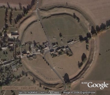
the Circles, and the Octagon
Study of ancient earthworks in
the Ohio
Valley, in particular of the grand Middle Ohio
River Valley sites, the Newark
Earthworks
and Marietta
Earthworks,
illustrate a variety of considerations.
Researchers have reported
numerous lunar
alignments at Newark, especially the Octagon's
alignments
to
lunar major rise and set horizon azimuths. In
1982 Horn
and Hively confronted the issue of speculation
in scientific writing
based on surveys with erroneous detail. They
resurveyed Newark and, in Geometry
and
Astronomy
in Prehistoric Ohio, introduced their
findings as
follows:
"Our analysis shows that the
earthworks
conform to a simple but precise geometric
construction based on a
single unit of length. Our work has also
revealed substantial evidence
that the earthworks may have been laid out at
least in part as a lunar
observatory."
However, the modern earthworks
are not
the ancient ones, they are the product of
multiple, undocumented
"restorations." Three surveys were conducted
prior to the restorations.
Hively and Horn admonish, "...no reliable
conclusions can be formed
from current survey alone." Middleton's 1887-88
survey assessing
geometrical regularity and previous survey
accuracy demonstrated the
unreliability (for precise quantitative
analysis) of earlier surveys.
Although primordial forest still covered the
Newark works in 1847, by
1887 Middleton was only able to produce surveys
of the surviving major
features remaining today, and plowing had
impacted parts of the
Octagon, but not the attached Observatory
Circle. Holmes' 1892 survey
precisely agreed with Middleton's Observatory
Circle 321.3 m mean
diameter measure, the "single unit of length"
cited by Horn and
Hively. Hence, this diameter is considered
a reasonably accurate
determination.
Horn and Hively report that
Middleton's
survey results agree with their
after-restoration survey "to within 30'
arc for azimuth measurements and to within 1 m
for distance
measurements." Horn and Hively also report
agreement with an
unpublished survey by Eddy in 1978. In sum,
sufficiently accurate
surveys of the two major constructs at Newark
(Newark Octagon and
Newark Circle) exist to accurately make several
analyses, including
assessing past alignment claims. This
suitability prevails in no small
part due to the grand scale and proportions of
the features, grand
enough even for comparison with global size.
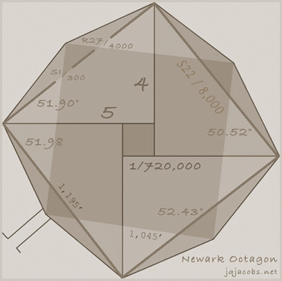
Middleton reported a 51.45°
azimuth
for the Observatory Circle (CIR/7 = 51.43°)
and a mean of
51.98° for the parallel earth banks between
the Octagon and
Observatory Circle. 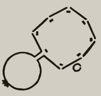 My GPS
readings produced a 51.52° azimuth from the
center of Observatory
Mound to the gateway at the opposite apex of the
Octagon work. I
fail to find mention of the CIR/7 angle in
Middleton or in subsequent
related literature. Hively and Horn mention the
7:1 ratio of the
Observatory Circle with the small Octagon Circle
without further
comment. Hively and Horn also warn, "the number
of alignments formed by
connecting arbitrary points in the structure is
so great that the
likelihood of generating chance alignments with
any astronomical
phenomena is disturbingly large." They then go
on to note 17 plausible
lunar alignments for Newark. My GPS
readings produced a 51.52° azimuth from the
center of Observatory
Mound to the gateway at the opposite apex of the
Octagon work. I
fail to find mention of the CIR/7 angle in
Middleton or in subsequent
related literature. Hively and Horn mention the
7:1 ratio of the
Observatory Circle with the small Octagon Circle
without further
comment. Hively and Horn also warn, "the number
of alignments formed by
connecting arbitrary points in the structure is
so great that the
likelihood of generating chance alignments with
any astronomical
phenomena is disturbingly large." They then go
on to note 17 plausible
lunar alignments for Newark.
In a preliminary study
Possible
Geodetic Properties and Relationships of Some
Monumental Earthworks in
the Middle Ohio Valley, I first considered
the local latitude to
longitude ratio for the Octagon and Observatory
Circle as a possible
reason for the earthwork's alignment. At Newark,
the distance ratio of
equal latitude and longitude degree distances is
about thirteen to ten
(= 1.301 : 1.0), forming angles of 52.45°
and 37.55.° This
angle was reported in the Newark surveys, but
without mention of the
simple local geodetic variable—the
proportions of equal angular measures in the
cardinal directions, axes
employed in latitude determination. Middle
Ohio Valley site
alignments may be due to their latitude to
longitude ratio angles, and
many of these have been assigned to lunar major
in previous studies
without discussion of the near coincidence of
these angles. In the
context of one-seventh and an octagon, I also
noted this angle
approximates the proportion of seven-eights
squared (1.306 : 1 =
52.56°) and lunar apogee-perigee squared—the
lunar
illumination
ratio (1.3025 : 1 = 52.48°). Plus, the two
squares formed by the Newark Octagon vertices
(using my GPS readings)
have a ratio of average sides approximating 7 :
8 (0.872 : 1.0).
The
Octagon
Alignments:
Astronomy, Geometry, or Geodesy
My Occam's razor choice to
explain the
Newark Octagon alignment has shifted several
times. From latitude to
longitude ratio (52.45°), I turned to the
more accurate CIR/7 and
5:4 triangle tangent (51.42857° vs.
51.3402°) angles. Laid out
on the geometric grounds at Newark we find the
same triangle formed by
the Monks Mound's latitude in relation to the
equator (a 5:4 triangle
with the geodetic radius forming the
hypotenuse). The angular
difference between 1/7 of circumference and 1.25
atan is slight. We
lack the survey accuracy to differentiate these
two angles in the
Newark alignments.
Using a larger scale, the earth
instead
of the earthwork, five-quarters atan is
emphasized by the latitude of
the largest earthen mound in the Americas,
downriver at Cahokia Mounds.
One-seventh is a feature in England, at
Stonehenge and Avebury across
the Atlantic. With two nearly-equal,
barely-discernible choices of
simple geometry, I preferred assigning the
reason for the alignment to
the 5:4 triangle tangent angle, the 'most
plausible' option on the
basis of cultural proximity and simple geometry.
As science goes, I knew
complexity might
intervene and that I might circle around,
proving my choice wrong. That
took only a few weeks. Octagons have eight
sections with adjoining
45° angles at their center. The radian
measure of a semicircle is
pi, and that of a 45° angle is pi/4.
Considering the azimuth
measured N of E, atan pi/4 is 38.1460.° The
atan of 4/pi equals
51.854° (also possibly the slope of Khufu's
pyramid in Egypt).
Thus, in addition to the hypothetical lunar
major alignment, there are
three possible geometric reasons, one geodetic
reason, and a lunar
reason to explain the monument azimuth. Now, I
wonder if the builders
were aware of all five of these, six with
seven-eights squared included. The
alignments of parts of the Octagon accurately
present several of the
possibilities. Thomas' survey reports angles of
51.53 and 50.75
degrees. The following graphic presents four
azimuths for the largest
inset square (determined with my GPS readings).
Alignment studies present a real
conundrum, and researchers easily overlook the
simplistic and focus on
the complex, temporally-varied astronomical
illumination. I learned the
wrong approach from the archaeoastronomy
literature, and the lesson
from direct experience at great temporal cost.
This essay intends to
divert others from wasting similar energy.
Illumination coincidences in
large scale
architecture actually do frequently evidence
astronomic alignments, and
for good reason. Surveying property and
establishing use lines, be it
today or in ancient times, is geodesy and
geodesy employs astronomy.
You cannot survey the earth without astronomy,
just as you cannot
arrive at the laws of gravitation without
elliptical orbit mathematics
and cosmographic measure. If a society uses
astronomic horizon points
to orient property lines, structures will
evidence astronomy. Simple.
That's a really acute Occam's razor: surveying
employs astronomy, subsequi,
of course there are alignments everywhere. And
some cultural systems do
use illumination lines instead of cardinal lines
to divide space.
Unraveling what is or is not an astronomical
alignment, or an
observatory, is part of the conundrum.
As in all science, complexity
enters the
equation eventually—there are yet more plausible
explanations for
alignments. The same reasoning repeats for
navigation. The methods are
more difficult on water, but everywhere people
have ever traveled using
navigation, astronomy lines were employed in
some form. Navigation has
function, and geodetic knowledge depends on
astronomical observation.
Before mechanical chronometers, navigation on
land or water was
possible using astronomy; the moon was the
chronometer. At certain
latitudes, with powerful tidal rip currents in
channels and near
islands, surviving water crossings can literally
depend on lunar
prediction, thus providing a functional
rationale for lunar calendars
and alignments.
The complex of many different
possibilities to explain alignments is a
multiplier of the
probabilities. There are other angles in the
same range as Newark's
lunar major, creating an entire complex of
mathematical possibilities
alone. Examples of these are the cosine of
latitude near Marden Henge
is 5:8 (51.3178°), and, on Windmill Hill
above Avebury, the local
longitude:latitude ratio is 5:8. To this, I
would add more complex
considerations, like the entire realm of
codified non-verbal
information in architecture, intentional
codification of data,
employing context for meaning, place as context
with meaning, and
myriad distinct cultural possibilities. Add
stars and constellations,
since every alignment points to two stellar
positions, and the
possibilities are dizzying in number, creating
the real conundrum.
I could not agree that the
Octagon lunar
alignments evidenced an observatory without
further proofs. At this
juncture, looking behind all the wonderful
coincidences was incumbent.
Alignments, the joyous poetics of light and
shadow on earthen geometry
in cosmic interplay had to be left behind to
refocus on the underlying
structure, the unity characterizing the cultural
expression. Just like
an astronomer on a quest to discover new planets
is ever alert for the
slightest misinformation—any hint of movement
anywhere on the stellar
backdrop of uniformity, with the remaining
archaeological record we are
also left with the task of assembling reason
from just bits of
information. Complexity presents unique
challenges to scientific
research, and the Octagon is a classic example
to add to the list. Once
a certain complexity is achieved, science by
sampling—polling instead
of voting, not counting every vote, and not
counting votes as
intended—can produce false conclusions.
How do we solve such a conundrum
and
discover the rhythm, the purpose behind the
light show? We scientists
scion, codifying divisions of unity, building a
foundation: taxa and
taxonomy. Observations are structured around a
research question, for
example, "What would distinguish an observatory
used to measure cosmic
scale from ordinary alignments?" My hand goes up
fast here. Two or
three observatories measuring parallax would be
quite useful.
Eventually astronomers build two observatories
and compare
observations. Employing parallax is a
fundamental and requisite step in
measuring cosmic scale.
This capability, simultaneous
observation
from two positions, should produce specific
geodetic evidence;
placement of an array, direct survey between
sites, evidence of
triangulation nets between sites, distant
hilltop bonfires to establish
accurate nocturnal geodetic references, concerns
with level in
geometric constructs, moats or water-leveled
features, large open
fields for geometers, lots of poles, towers, the
capacity to accurately
measure triangles with 500 to one proportions,
and more. Observations
at diverse stations need to be synchronized,
typically by signal fire
towers. Eventually, with greater sophistication,
observatories may be
placed across the continent or globe in precise,
known relationships.
The unity of such tasks leaves a mark. Such
evidence is found around
and between the major earthworks in the Middle
Ohio Valley.
In another approach, if a
culture had
astronomical observatories, parallels with known
historical societies
should be in evidence. Evidence from Newton's
perspective, high on the
shoulders of his four giants, should be
discernible. You have to
observe the moon with mathematical precision
before achieving Newton's
place on that ladder. You cannot pass Galileo's
insight without
thinking heliocentrically, or achieve Kepler's
understandings without
elliptical geometry. The computational
mathematics of modern
astronomical discoveries should be in evidence,
not just alignments.
And if these tools are unearthed by
archaeoastronomers, even this
evidence could still exist by coincidence, or
the tools discovered
could serve another function just as astronomic
lines in the landscape
might serve navigation and land use definition
functions instead of
astronomical ones.
Archaeogeodesy
and
Finding
Advanced Ancient Astronomy
The biggest questions impact all
researchers in a field, and waves move outward
from there. Can
mathematical evidence in the archaeological
record tell us something of
the history of science in Ohio before 1800? Or
in Prehispanic America,
in Neolithic Europe, and through the course of
prehistory everywhere?
Yes, it can. Mathematics and astronomy are
universal languages,
accessible to analysis. Can we conclude that
Stonehenge or Newark, or
their associated arrays, are indeed
observatories? Far more than
alignments are needed to make a firm conclusion.
I hope I have shown
that investigating claims is more difficult than
making them, as others
cited have also shown. Nonetheless, big
questions deserve some
perseverance, especially if they write new
history and right old
history. I stayed on this path longer, pondering
the complexities.
If demonstrating advanced
astronomy is
the research focus (mine is multidisciplinary),
the researcher can
refocus behind the alignments, on the
mathematics of astronomy and
cosmography, and on the requisite systematics.
Now, at the level of
science, the astronomer's chair is an ellipse on
a spinning earth, and
the moon is a constant foresight to the cosmos,
albeit a very
peripatetic one. Correctly referenced in space,
advanced analysis
begins, equating the precise math, local radius,
geodetic scale, cosmic
scale, calibrating motions, and constructing
site dimensions in planes,
angles, lines, and triangulation arrays. The
coordinate structures the
cosmos describes are naturally scissioned with
astronomic motions, quod
sciam quantities are accurately
revealed and intrinsically recorded by
luni-solar calendrics after a sufficient
temporal span of data
acquisition. The researcher takes the mental
steps the ancient
astronomers and calendar keepers took,
recreating enormous temporal
spans, reducing variables, factors and time to
modern equations—playing
with cyber-aedes in the aegis aeries of Jupiter,
Aethena, and the
Aepollices—inquisitio aequalis aeternus.
If a culture attains Galileo's
or
Kepler's insights, evidence should be there.
Obliquity and secular
polar shift may also date the geodetic traces of
observatories
evidencing those achievements, and, hopefully, a
trail of temporal
clues will also lead back in time. This is the
quest I found tempting.
The researcher's path has many obstacles, not
the least of which is the
inaccuracy of past methods and false
paradigms—not unlike the path of
the first astronomers, of Galileo, and of all
minds trapped in dark
ages.
I took steps learning astronomy
to
investigate codices, histories lost, and
cover-ups of the past.
Eventually I realized the steps historical
astronomers took inform
analysis in any prehistoric context. For
example, understanding
observer motion and elliptical planetary orbits
requires certain known,
definable mathematical capabilities.
Analytically, a inverse equation
prevails; evidence of specific understandings
infers certain threshold
capabilities, and uncovering capabilities infers
knowledge and
understandings.
"Show me they knew Kepler's
law," a
little voice on my shoulder whispered in my ear
to claims by
archaeoastronomers. That image repeats in
ancient pictographs. The
anthro's dilemma is clearly portrayed in the
Grand Gallery panel, by a
figure on each shoulder. The anthro's dilemna is
understanding that the
disparate voices on both shoulders are correct,
and, perhaps, understanding their
perspectives are different
because your head is in the way! We forget our
two eyes do not see the
same thing. Such is parallax shaved to
astronomical accuracy.
|
|
In 1984, at La Hacienda
in
Moab, a piece of the puzzle fell
into place for me while
observing new moon and Venus on the
horizon, simultaneously eclipsed by
the rotating sandstone fundament, the
horizon with a vertical cliff.
From my perspective both last specks of
light, moon and Venus,
disappeared at once, simultaneously with
precision. A minute
latter, from the next window, "The star
is disappearing." There and
then we directly understood the
proportions of our cosmos. Two arches,
four eyes, four words, and no more
measure nor telescope was needed to
know. From only a few feet apart with
entirely different perceptions,
parallax revealed the geometry, the
grand scale of Earth, Moon and
Venus.
|
These insights, as rocks and
light speak
them, were seen throughout time, and they evoked
understanding and
further inquiry. In poetry, this is how rocks
speak to animals. In
science, we divide and measure, often seeking
the means to run to the
other window first, with our monocular view
explained. The real work is
explaining the different views in a holistic
framework. We must rein in
a tendency to use number and language and
proclaim every single
perspective in linear language, without seeing
the non-verbal unity in
what the rocks say, not hearing that voice of
place. If you take the
thing apart, you can put it back together, and
the pieces must fit.
Divide it up wrong, create a false taxonomy, and
you've got Humpty
Dumpty for dinner. All the kings horses and all
the kings men cannot do
it, but the scientist must, or the circle back
to the question is never
complete. There is language and number, and
there is actuality. In the
end, the scientist must discern the actuality,
not the coincidences,
not just the statistical probabilities, but the
underlying unity.
Knowing the precise size of the
earth is
a very good beginning on the path of cosmic
discovery. It is a first
step in the use of astronomy, one employing
light angles to make a
simple geodetic determination using a triangle.
The size of the earth
was accurately known in remotest history,
divided by 365, 360,
corrected, redivided, lost to conquest and
reconquest, and found again,
etc. The builders at Newark attained great
milestones, they knew the
size of the earth and more, much more. Their
unit of length,
Observatory Circle's diameter, is a fraction of
the earth's
circumference, 1/125,000 (= 0.000008 CIR). The
distance from Newark to Marietta
is circumference divided
by days per year, as is their longitude
difference. In my archaeogeodesy
writings, I
also discuss more site-to-site relationships of
Newark, Marietta, and
other sites, further explaining my conclusion
that the builders at
Newark knew the size of the earth and much more.
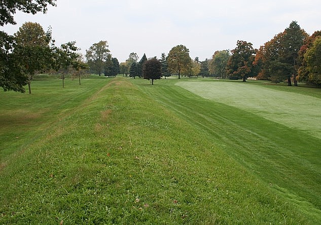
The Ohio chapter in science
history is
written with and on the earth itself, amidst the
fairways at
Moundbuilders Country Club in Newark and with
many other mounds and
earthworks. Thus they wrote their book, directly
upon the earth for all
time forward. Are the mounds of Ohio a codex or
observation records,
science permanently (they thought) inscribed on
the earth, or maybe
records from distant observatories? More
study is needed to
address these questions. My conclusion: Newark
and Marietta are parts
of one observatory, and we play and golf on a
geodetic codex.
Further
Reflections
Every culture makes smoke. Some
burn
books. Some have more smoke and mirrors, myths
not understood,
histories lost, and true history obfuscated or
covered up. I've choked
on smoke along the 1/36 of circumference from
Tenochtitlan to Chichen
Itza, along the 1/100 of circumference from Itza
to Tikal.
From the cosmic gardens of
Beijing to
Stonehenge and Newark we fly, spewing
hydrocarbon toxins upon the
world. From Kilimanjaro over Sanchi to Everest
we sail in metal boats
polluting our evolutionary garden. Nature's howl
from Everest ought to
echo around and around in Casa Rinconada, then
resonate back from Taos,
"STOP killing the ONE world, Scion. Get back in
the garden." I'm
choking on all the smoke and chemicals.
The world has never been
like this before and we fail to see much of the
past, our ancestoral
garden.
I feel as though I've read a
book monkeys
can read—the light and angles of the cosmos. I'm
happy sitting in my
window on time's mountain, seeing the world
today and the past with
more than one cultural and intellectual
perspective, free of the
paradigms and misconceptions of my youth. I grip
the umbilicus, ready
to return around that corner, a teller with
stories from other cultures
and times, using words and numbers, seeds
harvested with the roaming
scythe of long observations.
I remember trying to figure out
which way
the earth and moon move. I was a flatlander. Now
I see Everest and
Huascaran creep towards the equator, knowing the
system finds its own
equality, geodetic and otherwise, and all else
is just the punctuation.
One day mythologies will be taught with new
heroes and geodetic
terminology, not just the names of masters who
divided up the Aegean
and the slaves. One day, hopefully, humans will
breath clean, safe air
again, as prehistoric Ohioans did a mere 200
years ago, and the smoke
obfuscating lost history may clear.
Whether or not the American
Indians in
the Ohio Valley had climbed past Newton's step
on the ladder of
knowledge before their conquest and displacement
by 1800, and if so,
for how long, remains lost history, but only for
today. A book is
written on the earth. I'm working at reading it.
I'm still Finding
America and still puzzling
too. Attempting to bury the secrets of the
destruction is futile; you
cannot bury the thing when the whole earth is a
book. This
book—the archaeological record—will not burn,
but it is still being
bulldozed away to this day. This
destruction, this cover-up must
STOP.
If you have one inquisition you
need a
second one, to look from the other side also,
two eyes, two viewpoints,
two poles, two kinds of minds, two hemispheres,
one world. And like
astronomers of old traveling to record parallax
in distant lands, you
must eventually bring the second view back for
actuality to be
appreciated from the unity of diverse
perspectives.
"...Heart of Heaven, Heart of
the
Earth! Give us our descendants, our
succession, as long as the sun
shall move and there shall be light. Let it
dawn; let the day come!
Give us many good roads, flat roads! May the
people have peace, much
peace, and may they be happy; and give us good
life and useful
existence. Oh, thou Huracan, Chipi-Caculha,
Raxa-Caculha,
Chipi-nanavac, Raxa-nanavac, Vox, Hunahpu,
Tepeu, Gucumatz, Alom,
Qaholom, Xpiyacoc, Zmucane, grandmother of the
sun, grandmother of the
light, let there be dawn, and let the light
come!" Popol Vuh
|
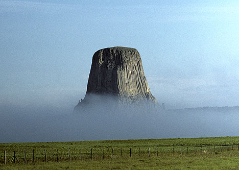 Sunrise at Mato
Tipila, 54.4487°
104.7155° Sunrise at Mato
Tipila, 54.4487°
104.7155°
|
Download Ancient
Sites
Calculators: Neolithic_Calc | ArchaeoGeodesy
Where and
when did
the first geodesists divide the world?
Was it Mount McKinley, Newgrange or Giza,
Avebury or Sumeria?
Was it the Cosmic Gardens of Beijing or at
Newark's Great Circle?
|
Newark
Archaeogeodesy
Assessing
Evidence of Geospatial
Intelligence in
the Americas
2009.01.09 -
In 1991, I first noted the arc
distance between Ohio's ancient Newark
and Marietta earthworks equaled
circumference (cir) of the earth
divided by days per year. ...
|
|