| 2023 ArchaeoBlog |
|
2023.01.30 - My annual routine, updating these two files, was completed at year's end. The v2023 versions are already updated one more time. I update these files during the year occasionally.
In the past year in Google Earth more areas of the Amazon with ancient earthworks were updated with higher resolution satellite imagery, allowing my first survey in some areas and resurvey in others. The above files and the Amazon Geoglyphs XLS are updated accordingly.  Amazon Geoglyphs 2023.10.12 - Updated Amazon Geoglyphs KML and XLS files are now online.
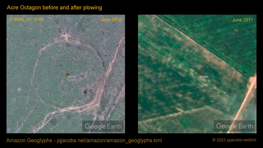
A feature of the new KML update is 46 aerial images enbedded in the placemark balloons, drone photos recently taken by Dr. Robert S. Walker. 2023.02.04 - One satellite image update in particular in Acrelandia clearly illustrates how different aerial satellite images produce different survey results and how important it is to examine as many satellite images as possible. The recent imagery updates also illustrate the optimal time in the annual vegetation and grazing cycle for satellite imagery to reveal the ancient earthworks and overcome a limitation of space archaeology in verdant regions. At the end of July the pastures are closely grazed and dry season vegetation variation is on display. Contrastingly, the nearby update with June 20, 2022 imagery around Placido de Castro did not reveal more than previous surveys. The new ../acrelandia_2022_survey.kml placemarks file illustrates how many additional earthworks were revealed in the survey area, perhaps better stated as revealing how many may remain hidden in so many other satellite images, the reason I am making this point and providing the KML. We will know the full extent of the archaeology once the region has complete lidar surveying, given of course, if the evidence is not plowed away. Too often resurvey also reveals illegal earthwork destruction in recent years. One earthworks recently impacted by illegal destruction is a very unique geoglyph, one I dubbed the Acre Octagon. So far it is the only known octagon geoglyph in the Amazon, which alone makes it a significant cultural treasure. I first placemarked the site in 2010, before the destruction. The 2010.06.30 Google Earth satellite image clearly shows the 150-meter-wide outline in a pasture, revealed after destruction of the forest. Illegal damage by agricultural plowing is evident in the 2016 satellite image.
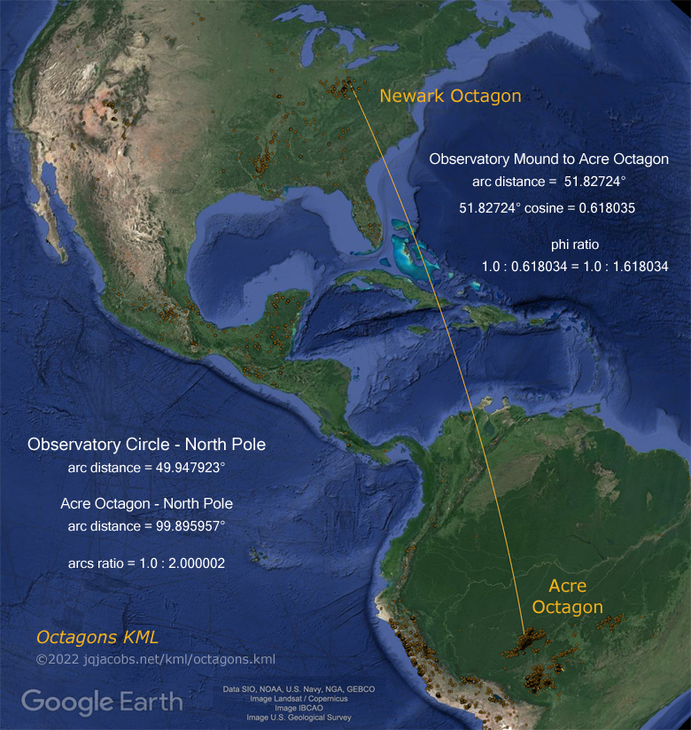
I wish I had examined the relationship of the Acre Octagon to Newark Octagon a decade earlier. In 2005, I acquired GPS data at the Newark Earthworks. Only in May of 2022, when I finally examined the spatial relationship of the Acre Octagon with Newark Octagon, did I note the cosine of their arc distance equals phi. Perhaps earlier discovery and publishing of this knowledge could have averted the plowing of the geoglyph.
I also noticed Acre Octagon is twice as far from the North Pole as Newark Octagon. The center-on-center margin of error from Observatory Circle to Acre Octagon is only six meters, about the expected margin of error for high resolution Google Earth derived coordinates. Tectonic shift since their construction has altered their relationship by more than that, albeit Newark Earthworks is one of those rare locations with almost no tectonic change in latitude over time.
For more results of the octagon relationships study open the Octagons KLM placemarks file in Google Earth. Download: http://www.jqjacobs.net/kml/octagons.kml
2023.02.16 - Since 2016, Anthropology Day is observed globally every third Thursday of February to share the wonders of anthropology, the science of humanity. That means I should share some of what I'm researching. A good portion of the past year I worked on databasing past work. Having a database of study results facilitated updating the Ancient Monument Phi Ratios KML file. New results from the past year, including the Acre Octagon finding, required attending to an update.
Previous Years Linked Below |

