Continuing Entries
Datum Updates: March 19, 2006.
After determining more accurate coordinates for Avebury, Silbury
Hill and Windmill Hill, I determined their site-to-site relationships
(updated/reflected in results discussed above). Additionally,
the Avebury to Silbury Hill arc equals 0.01307° (0.00100 R27), 1/1000th
of lunar orbit per earth rotation. The Windmill Hill to Silbury
Hill arc equals 0.02900° or 1/1000 of earth orbit per
full moon period (0.00100 S29). These two arc distances and
the placement of the three monuments presents precise fractions
of astrogeodetic modules based on the three fundamental cosmic
motions. The fundamental astronomy, the modules, and notation
are further explained in the Archaeogeodesy
series.
GPS Updates: April 24, 2006.
The Newgrange coordinate has been updated with a GPS reading
for the center of Newgrange Mound. The results above now
reflect this change. Knowth Mound, Dowth Mound, and Dowth
Henges GPS coordinates were also obtained. The arc from Knowth
Mound to Windmill Hill equals 3.60006° or CIR/99.9985,
an excess of only 6.1 m. And the distance from Knowth to
Newgrange equals 1/1000 of earth's diameter, therefore the
distance from Newgrange to Windmill Hill is 314.19
(100 pi) times
that from Newgrange to Knowth. From Avebury to Dowth Henge
equals 3.59647 degrees.
Research Update: Sept. 9, 2006.
Once in a while I get a whim and follow it. And advancing technology
and new interactive online information processing capabilities
are seemingly having a synergistic effect on research. I found
myself flying around in the Thornborough Moor vicinity thanks
to Google Earth, this after noting a possible lunar major alignment
of two of the Thornborough henges (more on this soon in a Thornborough page).
I aligned the henges and tilted down, then followed the line
to the NW horizon, and then onward until serendipitously flying
over the highest point on the Isle, Ben Nevis. I rotated back,
aligned the display to Thornborough and flew back, over
Ben Nevis, directly over the many Thornborough Moor henges and,
continuing with the whim, onward with curiousity. I arrived at
Mont Blanc, the highest point in Western Europe.
 Hovering
in cyberspace above Mont Blanc, another whim came to mind. I
wanted to know if the Newgrange and Avebury complexes aligned
on the highest point in Western Europe. Of course, they do! GPS
coordinates for Mont Blanc confirm the obvious line. A line from
Knowth and Newgrange passes between Avebury and Silbury Hill
over the Sanctuary, where the respective bearings angles sum
179.98 degrees. Also, the Sanctuary arc distance from Mont Blanc
is precisely 8.0° (CIR/45). Hovering
in cyberspace above Mont Blanc, another whim came to mind. I
wanted to know if the Newgrange and Avebury complexes aligned
on the highest point in Western Europe. Of course, they do! GPS
coordinates for Mont Blanc confirm the obvious line. A line from
Knowth and Newgrange passes between Avebury and Silbury Hill
over the Sanctuary, where the respective bearings angles sum
179.98 degrees. Also, the Sanctuary arc distance from Mont Blanc
is precisely 8.0° (CIR/45).
Next whim, check the illumination angles. Given Newgrange's
well-known winter solstice passage illumination, winter solstice
was the obvious suspect. At Avebury the bearing of
130.82° to Mont Blanc matches the winter solstice angle
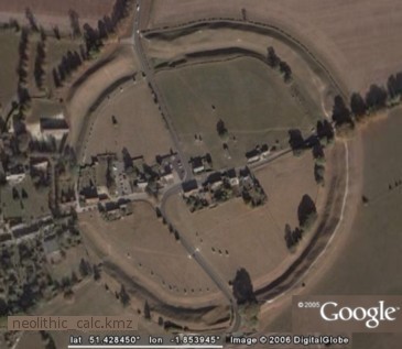
during the Neolithic occupation period. Using Victor Reijs'
GeoAstro calculator (in Neolithic
Calc),
Avebury's winter solstice angle was 130.82° given epoch
-3300 and altitude 0.0. Avebury's summer solstice sunset,
in the direction of Newgrange (bearing 49.29° W. of
N.) was 49.29° given epoch
-2700 and altitude 0.0. This date concurs with radiocarbon
dating of Avebury and Newgrange. From Windmill Hill the
bearing is 49.33° to
Newgrange and Knowth.
It goes like this, right? Observation,
pattern, hypothesis, prediction, test, observe...the
cycle repeats... until finally, formulate hypothesis if supportable.
As these intriguing relationships mount in number and predictions
are confirmed, so also concerns with formulating hypotheses
become more pressing. In light of current findings, "major
monuments may evidence ancient geodetic placemarking" seems
a reasonable idea to subject to testing. Of course,
that's only possible if the sites survive modern developments.
Research Update: Jan. 22, 2007.
Once in a while I get a whim and follow it. And interactive
online discourse enabled me to follow this one.
The updated ArchaeoGeodesy embeds
Victor Reijs' GeoAstro, a
declinations calculator. Victor and I dialogue archaeocosmology
and fundamental astronomy from years back. His interest in
celestial alignments and his critique of my more cartographic
approach to ancient monuments led to embedding GeoAstro in
Neolithic Calc and in archaeogeodesy.xls. This useful synergy
resulted in a new finding.
I'm getting to the whim. To celebrate the 20th anniversary
of defining and quantifying the astrogeodetic modules used
in my archaeogeodesy studies, I updated ArchaeoGeodesy with v2007.01.11,
complete with an eclipse calculator. As I final-checked the
worksheets, I noticed the GeoAstro output for obliquity
angle was quite near 24 degrees. Here's the whim. I
thought, "What if
the Ancients used the obliquity
angle as a temporal benchmark." I
did not check immediately—busy with family, monumental
politics, repairing the calendar, anniversaries and all.
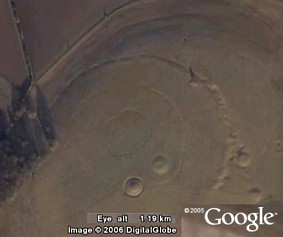
The Neolithic Thornborough 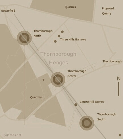 landscape
has been horribly wasted by gravel quarries, with mining
intruding upon the monuments, not unlike Woodhenge
at Cahokia. Quarry expansion plans may destroy the Thornborough
landscape further. Many henges in Europe, like earthworks
in North America, are simply gone forever. So many pages
of the book burning at once these days, it's fueling global
warming! So I turned attention to updating the Thornborough
page, to provide more information for that preservation
struggle. landscape
has been horribly wasted by gravel quarries, with mining
intruding upon the monuments, not unlike Woodhenge
at Cahokia. Quarry expansion plans may destroy the Thornborough
landscape further. Many henges in Europe, like earthworks
in North America, are simply gone forever. So many pages
of the book burning at once these days, it's fueling global
warming! So I turned attention to updating the Thornborough
page, to provide more information for that preservation
struggle.
I set the site variables to Thornborough South, Ben
Nevis, and Devil's Arrow, adjusted the epoch to -2758.325
to set obliquity to 24 degrees, and set the altitude to 0.0
degrees. Thus, the illumination declinations present the
level horizon position of the center of the sun and moon
when obliquity equaled 24 degrees. The result was a very
accurate match between Thornborough South lunar major extrema
and the bearings to Ben Nevis. A collegue expressed doubt,
plus there is no Neolithic monument on Ben Nevis. So I checked
a second alignment, Avebury and Newgrange of course.
Avebury and Newgrange have something striking in common.
They have three megalthic stone circles of the same diameter,
one surrounding the Newgrange passage tumulus, two within
the earthwork and large stone circle at Avebury. The
Avebury to Newgrange bearing accurately matches the
summer solstice sunset bearing using the same settings. Meanwhile,
Victor has been improving the declination calculation tools.
With his new formulations, the Avebury to Newgrange alignment
is a perfect match.
At Avebury, when obliquity equaled
precisely 24 degrees,
the level summer solstice sunset pointed precisely to Newgrange.
Other
questions collegues raised include "Why 0.0 altitude?" and "Why
the center of the celestial sphere?" In geometry,
why level is an easy question to answer. That is how
the math is accomplished, using perpendicular axis and planes.
Level is the natural, local geodetic reference also, and
determinable with water. It is gravity referenced. To
the question regarding pointing at the center of the object,
I had to reply, "Well,
when you point at something...." Hence, again the
center of gravity is the reference.
If this discovery proves to be a temporal benchmark built
into the Neolithic complex (and more widely, like Egypt,
etc.) the
implications are considerable. I will be giving this finding
further scrutiny and will report later. I'm hoping that
the 24 degrees obliquity angle will prove to be a temporal
reference for the placement/arrangement of the monuments,
a key to a very large door in the dark halls of prehistoric
science. I'm going to open that door now, expecting the illumination
will end a period of darkness. Caution, synergy at work!
I should also mention something perhaps not trivial
or coincidence. Silbury Hill and Marlborough Mound, the two
tallest European mounds, are only 100 m from due east-west
of each other, and they are spaced 1/4,800th of circumference
apart. The two tallest menhirs in the British Isle, Rudston
Monolith and Devils Arrow, are more precisely an east-west
line. The arc distance from Devils Arrow to Thornborough
Center equals 1/2,400th of circumference. There comes a point
when hypothesis testing simply gives way to just reading
the book.
Additional Coordinates: Sept. 30, 2007
Google Earth has updated
the aerial imagery for the Bend of the Boyne area. New coordinates
and site codes follow below. The three Boyne passage mounds
have lunar minor alignments (within a few meters of accuracy)
given 24 degree obliquity and zero altitude:
Bearing
knotu - newtu = 124.780°
knotu lunar minor = 124.371°
|
Bearing newtu - dowtu = 58.547°
newtu lunar minor = 58.720°
|
Knowth tumulus is pictured in the following
image. 
| Discourse:
Collected discussion group postings.
|
|
 Archaeogeodesy,
as a new and developing area of scientific inquiry, illustrates
how decisions impacting ancient monuments are made before science
develops the tools required to fully study and understand what
is being destroyed. The classic example of this dilemna is
the burning of the Mayan codices due to religious paradigms;
the texts were considered false religion. Today,
from three surviving books, the codices are known to be scientific,
in fact, the most advanced astronomical texts from that time.
From my archaeological viewpoint, an ancient book written on
the earth, a geodetic codex, is being destroyed in our time.
Our prevailing 'scientific' paradigm is the sum, to a large
degree, of beliefs in our time, reflecting ignorance of the
past and of the purpose of the Neolithic monuments. What has
changed is the scale of the codex being burned.
Archaeogeodesy,
as a new and developing area of scientific inquiry, illustrates
how decisions impacting ancient monuments are made before science
develops the tools required to fully study and understand what
is being destroyed. The classic example of this dilemna is
the burning of the Mayan codices due to religious paradigms;
the texts were considered false religion. Today,
from three surviving books, the codices are known to be scientific,
in fact, the most advanced astronomical texts from that time.
From my archaeological viewpoint, an ancient book written on
the earth, a geodetic codex, is being destroyed in our time.
Our prevailing 'scientific' paradigm is the sum, to a large
degree, of beliefs in our time, reflecting ignorance of the
past and of the purpose of the Neolithic monuments. What has
changed is the scale of the codex being burned.