|
Besh-Ba-Gowah Archaeological Park
Globe, Arizona


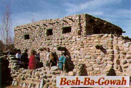
At Besh-Ba-Gowah Archaeological Park in Globe, Arizona, visitors
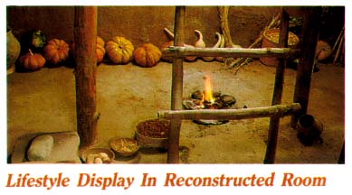
walk through a 700-year-old Salado Culture pueblo, climb ladders to
second story rooms and view the typical furnishings of the era. Numerous
artifacts of this remarkably advanced culture are also displayed in
the Besh-Ba-Gowah Museum. Besh-Ba-Gowah Pueblo is located at the confluence
of Pinal Creek and Ice House Canyon Wash, south of present-day Globe,
Arizona. Besh-Ba-Gowah has one of the largest single site archaeological
collections in the southwest and is one of the most significant finds
of Southwest archaeology. It is one of the largest and most complex
of the Salado communities. Archaeologists consider Besh-Ba-Gowah a
ceremonial, redistribution and food storage complex. Salado Culture
is identified as the cultural period from 1150 to 1450 in the Tonto
Basin.
Contents:
 Ecology Ecology
During the prehistoric era a continually flowing spring flowed near
the ruin. Pinal Creek, just below the ruin, flowed all year and contained
fish. Pinal Creek is located in the north slope foothills of the Pinal
Mountains and drains to the Salt River. The Pinal mountains attain
over 8,000 feet in elevation and support a pine forest. Snow was visible
from the ruins on March 11, 1998, the day of a recent visit.
Besh-Ba-Gowah is situated at 3590 f.a.s.l. Most of the annual 18 inches
of rain falls in the summer monsoon season, July and August. Four
inches falls during the winter. The growing season is about 228 days
long. Corn must be harvested by the Fall equinox to avoid molding.
The immediate local ecology lies between the Upper Sonoran Life Zone
and the Transition Life Zone. Readily accessible plant zones also
include Desert-Grassland and Desert Riparian. Lower and higher altitudes
are easily accessible and the prehistoric occupants enjoyed a wide
range of natural resources.
The Prehistoric Economy
 Cultivated
food crops included corn, squash, pumpkins, beans. Prehistoric stone
lined irrigation ditches were cleaned out and used by modern settlers.
Three reservoirs on elevated mounds are also known. Wild plants gathered
were of primary importance to survival. Genera utilized were Agave,
Yucca, Dasylirium, Opuntia, Mammilaria, Prosopis, Acacia, Larrea,
Quercus, Simmodsia, Populus, Pinus, Juniperus, Juglens, Celtis, Vitis,
Amaranthus, and Phragmites. Cultivated
food crops included corn, squash, pumpkins, beans. Prehistoric stone
lined irrigation ditches were cleaned out and used by modern settlers.
Three reservoirs on elevated mounds are also known. Wild plants gathered
were of primary importance to survival. Genera utilized were Agave,
Yucca, Dasylirium, Opuntia, Mammilaria, Prosopis, Acacia, Larrea,
Quercus, Simmodsia, Populus, Pinus, Juniperus, Juglens, Celtis, Vitis,
Amaranthus, and Phragmites.
A major trade route from Casas Grandes, Chihuahua, Mexico proceeded
up the San Pedro River drainage and passed along Pinal Creek en route
to the Salado River. The trade route was in use from 1100 to 1450
AD. The largest pueblos on Pinal Creek are viewed as having been cosmopolitan
trade centers. Exports included ground pigments, turquoise, beads,
and ceramic bowls. Import included shells from the Gulf of Mexico,
the Pacific Ocean and the Gulf of Mexico. Cotton from lower altitudes
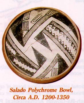
was woven into fine cloth. The Besh-Ba-Gowah potters were masters
of the craft. The apex of their product is Gila Polychrome. Salado
Culture pottery has the largest areal distribution of any Southwest
ware.
Pinal Creek Prehistory
Salado occupation is equated to the 1225 to 1400 AD period. The previous
temporal phase is identified with the regional Hohokam Culture. Salado
overlays Hohokam sites and a continuity of occupation is evidenced.
Hohokam pit houses under Besh-Ba-Gowah date to the 550 AD. A Hohokam
village on the site dates from 800 to 1150 A.D. Continuous occupation
of the area is evidenced from 750.
On Pinal Creek a group of eight Salado Culture pueblos were constructed.
Gila Pueblo, located about a mile upstream from Besh-Ba-Gowah, is
the type site of the Salado Culture. Gila Pueblo, the largest nucleated
settlement along Pinal Creek, had two story sections and possibly
three and four story sections. One hundred small hamlets and dozens
of villages were also found in the area. In the vicinity there are
20 to 70 sites per square mile.
Gila Pueblo developed around 1225. Arrowhead evidence indicates an
attack from outsiders around 1260. This is the first evidence of raiding.
Fire destroyed the pueblo at that time. Gila Pueblo was destroyed
by earthquake and another fire in 1340. The pueblo was attacked at
the same time as the earthquake destruction. Under 1.5 feet of rumbled
archaeologists found unburied bodies. Gila and Besh-Ba-Gowah may have
fought over water resources. A severe drought struck the region from
1276 to 1299.
Besh Ba Gowah was also destroyed by the earthquake and a fire in
1340. Both pueblos were rebuilt in 1345. Five to six building phases
are known from 1225 to 1400. The final fall of Gila Pueblo in 1430
was due to a fourth attack and fire.
Ruin Description
Besh-Ba-Gowah had about 400 rooms, of these about 250 were ground
floor rooms. Precise numbers are impossible due to modern destruction
of sections. Entrance to the pueblo was via a long narrow ground level
corridor covered by the second level. The corridor opened onto the
main plaza. This may have had defensive purpose.
 The
present day interpretive trail uses plaques are used to inform the
visitor. It begins with the ancient entrance way to the main plaza.
The main plaza measures 12 x 27 m. About 150 elaborate burials were
placed under the plaza. Hereditary high status is suspected from burial
evidence in the plaza. The ruins had very few doors. Room access was
by by roof hatchways with ladders. Several reconstructed rooms with
prehistoric contents are featured. The
present day interpretive trail uses plaques are used to inform the
visitor. It begins with the ancient entrance way to the main plaza.
The main plaza measures 12 x 27 m. About 150 elaborate burials were
placed under the plaza. Hereditary high status is suspected from burial
evidence in the plaza. The ruins had very few doors. Room access was
by by roof hatchways with ladders. Several reconstructed rooms with
prehistoric contents are featured.
Cross-sections illustrate the roof construction of logs covered with
layers of reeds, mats and a thick coat of mud. The trail leads past
the largest room in the pueblo, the so-called ceremonial room. A sipapu
filled with turquoise dust and covered with a large quartz crystal
was found in the room. The room contains built-in benches at various
levels, four large roof support posts and an altar on the east wall.
Another unique feature of the pueblo is a small platform mound.
Construction is of granite stone cobble with adobe mortar covered
with calcareous adobe plaster which produces a white finish. Walls
are over one foot thick.
Modern History
Besh-Ba-Gowah is an Apache work meaning "Place of Metals," and refers
to modern mining activity. First archaeological investigation was
by Adolf F. Bandelier in 1883. Bandelier surveyed the ruin and produced
a map. In 1935 excavation was begun. Complete excavation of the surface
rooms was eventually accomplished. Three hundred and fifty burials were
found. The project ended in 1940 and results have not been published due
to the untimely death of the project director.
Half of the pueblo ruin has been bulldozed. The north quarter of
the ruin and parts of the east and west edges have been bulldozed.
In 1948 the Army Corps of Engineers bulldozed part of a ruin to smooth
an area for a Boy Scout gathering. In 1982 the eastern edge was bulldozed
for a softball field. The ruin is part of a city park.
Besh-Ba-Gowah Museum
Inside the museum two models of the ruins are presented. One shows
the present condition. The other is a hypothetical reconstruction
of the pueblo in 1325 A.D. It shows 20 courtyards and 2 three story
sections. One of the displays illustrates the archaeologist's tool
kit.
Stone items on display include manos and metates, delicate carved
stone palettes, stone axes and hoes, obsidian points, turquoise beads,
local minerals and a bow drill for bead making. Shell jewelry evidences
trading networks extending to the Gulf of Mexico and the Pacific Ocean.
Fabric artifacts include woven baskets and mats, sandals woven from
yucca leaves, and fine woven cloth.
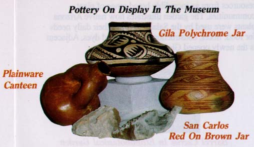
One wall of the museum is covered with shelves of ancient pottery
two pieces deep. A wide and diverse range of pottery includes red
and white ware and plain and decorated pots. Besh-Ba-Gowah has a high
percentage of decorated ware. The painted wares include Gila, Pinto
and Tonto polychromes. Some Gila polychrome have Mimbres-like designs
of stylized bird, insect and animal motifs. A unique type of local
pottery is the donut-shaped canteen.

The museum includes an excellent Bookstore and Gift Shop and a small
theater. Videos inform visitors about the ancient cultures and the
ruins. An excellent assortment of informative books and scientific
journals can be accessed by visitors. A new larger theater is near
completion. It will be able to seat the large school groups which
frequent the site.

Sources:
Besh-Ba-Gowah Archaeological Park, Ruins and Museum, Brochure and
Museum displays, City of Globe, Arizona.
McKusick, Charmion R. and Jon Nathan Young, The Gila River Salado,
Salado Chapter Arizona Archaeological Society, Globe, Arizona, 1997.
Ruin stabilization and Park Development for Besh Ba Gowah Pueblo,
Compiled by John W. Hohmann, Studies in Western Archaeology Number
1, Cultural Resources group, Louis Berger & Associates, Inc.,
Phoenix, Arizona, 1990.
Getting There
The route to Besh-Ba-Gowah is well signed, beginning on U. S. 60
in Globe. From Phoenix U. S. 60 is a scenic drive with views of the
Superstition Mountains, Weaver's Needle, Picketpost Mountain and the
Pinal Mountains. Boyce Thompsom Arboretum is also on the route and
is a highly recommended stop.
|
