| Landscape
Geometry of the 'Cursus' and Stonehenge |
2008.06.12 - I found a 5:6 ratio in arc distances from Stonehenge to the Cursus termini, with 1:1.00004 accuracy.
Stonehenge is in the news again, this time due to new dating of the "Cursus".
Interpretation, an often less-than-scientific aspect of the science of archaeology, shifts like desert sand in the winds of time. Sometimes the shifts are due to incontrovertable evidence, sometimes due to fads like New Age "thinking." Often, interpretation evidences more about the thinker and the times than the past. Centuries ago, Stukeley first described the "cursus" as a race-course for charioteers populated with innumerable multitudes attending solemnities. His cursus interpretation (cursus, Latin, a race, race track, course) remains as an enrenched misnomer in the archaeology lexicon. British astronomer Sir J. Norman Lockyer, a founder of astro-physics and founder of the journal Nature, published The Dawn of Astronomy in 1894. Lockyer, after noting the midsummer sunset axis at Karnak, inaccurately calculated the date for Stonehenge based on midsummer's sunrise over the Heel Stone. Lockyer published Stonehenge and Other British Monuments Astronomically Considered in 1906. He pioneered the concept of monument orientation towards the sun, moon, or stars on the horizon on a particular day, earning him a rank as a founder of archaeoastronomy. I noticed the Heel Stone azimuth is precisely 1/7th of circumference east of north, an empirical fact open to interpretation. I addressed this in Temporal Epoch Calculations. Lockyer also incorrectly dated the cursus based on the Pleiades alignment around 2000 BC. His example continues to be followed, even by serious scientists, and often with no evidence beyond the simple coincidence of whatever an alignment roughly points to as the basis for date-reaching and an interpretation. Several later authors pointed out the Cursus aligns with Woodhenge, even though that aligment is off by degrees. With alignment interpretations, one not infrequent and rarely challenged problem is the "horseshoes and atomic bombs" imbroglio—in other words, when is close close enough. When hypothesizing science, close is NOT good enough!
After reading the news report, I examined the Stonehenge and Cursus archaeogeodesy, using National Monument Report (NMR) coordinate data (in the table below). The results proved interesting. I found a 5:6 ratio in arc distances from Stonehenge to the Cursus termini, with 1:1.00004 accuracy. From Stonehenge to the west terminus is 0.01338 degrees, to the east terminus is 0.016056 degrees. The arc distance between the cursus' termini is 0.02513 degrees, about 2.8 km. The arc distance from Stonehenge to the Cursus W terminus (0.01338° = 0.00050 S22) matches the Thornborough spacing (+/- 10 m, accuracy 1:1.0067). Close enough? Not really. What are the methods employed? What do the coordinates really represent? The Stonehenge NMR coordinate (coded stonh) is likely a benchmark for archeological surveys. It is visibly not the center of the monument. Likewise for the cursus termini, where no actual cursus monuments are readily visible (barrows are). Also, the termini were rebuilt several times. The results are "close enough" to warrant taking a more refined approach, to employ methods suitable to the questions posed and the hypothesis considered. If the hypothesis is "the Stonehenge landscape evidences planned geometric construction" then accuracy should be to the level humans are capable of surveying and measuring. Google Earth (GE), a free download, is relatively accurate in Britain, as are topographic surveys of the region. Using the online topographic service at magic.gov.uk and the nearby.org.uk online converter to produce WGS84 reference system cordinates, the Stonehenge centerpoint results (51.17885, -1.82621) confirm the coordinates I determined with GE (stone 51.178856, -1.826172). Numerous other monument coordinates have demonstated that GE is accurate in this region. Nonetheless, accurate GPS is certainly the preferred method of determining monument coordinates. As is often the case in archaeology, digging deeper is required, including into survey and excavation reports and previous publications, and, to utilize better methods, into deeper pockets. English Heritage is reassessing the over 150 known cursuses and bank barrows in England, most now only cropmarks, with a few surviving as earthworks. Some are very long, or less than 250 m long; some survived at least 1,000 years, others apparently were not maintained; some lines are straight, others are irregular.
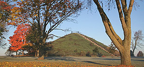
Cursuses are among the oldest landmarks and the most substantial prehistoric constructions in Britain. The Dorset Cursus traverses almost 10 km, and is over 100 m wide. These very long rectangular enclosures have near continuous boundaries of earthen banks and an exterior ditch. Cursuses are also some of the oldest monumental constructs in the world. They remain enigmatic even though much speculative interpretation has been published.
I am, of course, naturally skeptical of any interpretation that purports the thinking of cultures long past. The thinking of people right next to me, in one of my own cultures, is often too much of a mystery. Archaeology epitomizes the concept of sampling. All we ever have is a fragment of the past, and the smallest of samples is typically the case. While McOmish does wander about the interpretation landscape, I think some of his ideas appeal to reason.
Perhaps demarcation of communal space and community claims to place can explain a lot about monuments. Mystery arises in a vacuum, has life amidst ignorance, and seems to thrive on antiquity. Without knowledge of a culture's land ownership patterns, private and communal property ideation, land use decision processes, property and boundary demarcation methods, inheritance, and related concepts, we are left with mystery, at best. And so, we search for patterns with the hope of finding clues in this void of knowledge. In the context of the tiny slice of the past we are left with, our own culture and time seem to have more of a determinative outcome on our interpretation of the patterns we detect than actual evidence does.
Sites Considered The Cursus - (from NMR Monument Report) is a Neolithic monument comprising a long, narrow earthwork enclosure about 2.7 km long, varying in width from 100m to 150m, orientated roughly east-west, and passing within circa 700m of Stonehenge. The ends of The Cursus are squared with rounded corners. Two round barrows lie within the cursus at the western end. Much of the cursus bank and ditch survives as earthworks, the bank to a maximum height of 0.4 metres, and 6.5 metres width. Excavations occurred in 1947, 1959, and 1983, but dating evidence was limited. The 1947 excavations, located on the south side, revealed the ditch was flat-bottomed with steep-sides, 1.8m wide and up to 0.75m deep. A berm 4.6m wide and 0.4m high separated the bank and ditch. The ditch at the western end was larger, up to 2.75m wide and 2m deep with a wider berm, in addition to an external bank. The Cursus remains visible as a slight earthwork and a cropmark on aerial photographs, and has been mapped by both RCHME's Salisbury Plain Training Area NMP and EH's Stonehenge WHS Mapping Project. The Lessor Cursus - (from NMR Monument Report) is a Neolithic cursus comprising a rectangular enclosure, orientated west-south-west to east-north east, and 400 m long by 60 m wide situated along the summit of a flat-topped ridge. The eastern end is open. Aerial photography shows the visible earthwork defined by a ditch with internal bank in 1934 was levelled by 1954. A bank and ditch crossed the cursus circa 200 m from the western end. Excavations in 1983 suggest two phases of construction, the first phase its eastern end defined by the cross ditch and bank, circa 200 m by 60 m. The second phase sees the extension eastwards, with enlargement of ditches and banks. The few artefacts include a formal deposit of antlers, including picks in the phase 2 southern ditch, radiocarbon dated to 3640-3040 BC. The Lesser Cursus was mapped by both RCHME's Salisbury Plain Training Area NMP and EH's Stonehenge WHS Mapping Project.
2011.11.30 - Again, Stonehenge is in the news, along with the Cursus. With ground-penetrating radar and geophysical imaging, two large pits were noted below the surface. Archaeologist Vince Gaffney reports from the Heel Stone the pits align with the summer solstice rising and setting. Also, the midpoint between the pits is north of Stonehenge, albeit precision is apparently not yet specified. With myrriad headlines created for a news story, the line between fact and interpretation is blurred. A one sentence speculation about possible "processions within the Cursus" is now fully populated with actors and their beliefs. My online search produced interpretive terms such as sun worship, an ancient midsummer ceremony, Stonehenge mystery, Site Was Sacred For Sun Worship, a celestial procession at Stonehenge, Sun Celebrations at Stonehenge, a Sun-worship site, Stone worshipping, magical ancient Britain, ancient centre of ritual, and more. The Stonehenge Hidden Landscapes Project: Virtual Excavation & Digital Recreation Placemarks: stonehenge.kml
|

