Selected Writings
I compiled the writings and graphics below from my domain into this single web page primarily to query publishers
and agents. At the same time I've sought to provide some order to the ideas and study results presented.
|
|
| Chavin de Huantar Archaeogeodesy | Astronomy Fundamentals
... There came a point when I realized apparent ancient knowledge exceeded contemporary understanding of how to determine the knowledge. Forced to consider how their achievements could be accomplished and vexed by knowing a solution must exist, I finally overcame present-day paradigms and biases and arrived at an elegantly simple solution, one which should have been apparent all along to myself and Western astronomy. This astronomical reasoning exercise repeated my geodetic experience with longitude determination. Solving longitude is far easier with fewer unknowns, likewise with astronomy. On land, time and place are not unknown so longitude determination is simplified, plus you are not drifting on a ship so you can take centuries to refine accuracy from a fixed position such as at Chavin's known latitude. With heliocentric astronomy, rotation and orbits are not unknowns and thus resolving astronomy constants is straightforward, was possible thousands of years ago, and with centuries of observations can achieve precision. Geocentrism obfuscates earth's rotation and thus the key ratio of lunar orbits per rotation (0.036501 circumference) and the solution.
How precise astronomy constants were accessible to ancient astronomers can be summarized in one paragraph. Eclipses enable precisely observing the ratio of lunar synodic to lunar orbits. Using a short term example, just one Metonic eclipse cycle (Table 3), with 254 lunar orbits equating with 235.000467 synodic periods, 18.999533 fewer moons, we can deduce that 18.999533 solar orbits have completed during 254 lunar orbits and by division arrive at 13.368750 lunar orbits per solar orbit (Chavin epoch UT values, 0.0748013 solar orbits per lunar orbit). From a tally of earth rotations in 254 lunar orbits, the value of rotations per solar orbit (ro) easily computes, with 6958.703831 divided by 18.999533 equaling 366.256576. Solving rotations per orbit resolves all three fundamental motions and knowing there is one less day than rotation per orbit allows deducing the number of days per orbit. ....
| Naked Eye Determination of Rotations per Orbit |
|
| 235 moons = 6958.689997 rotations |
| 254 lunar orbits = 6958.703831 rotations |
| 235 : 6958.689997 = 235.000467 : 6958.703831 |
| 254.0 - 235.000467 = 18.999533 orbits |
| 6,958.703831 rotations / 18.999533 orbits = 366.256576 ro |
|
|
|
AeGeo Programming Code
Throughout the writings and in the applications I use my own AeGeo Programming Code for astronomy terms. AeGeo language also includes terse terms to represent more than 8,500 site latitude and longitude complex numbers.
|
|
| Eclipses, Cosmic Clockwork of the Ancients | ... Lunar orbits are most easily referenced to the stars. Each time the moon moves past a specific star, it has circled the earth once. Each time a specific star passes overhead, the earth has rotated once. By definition, lunar orbits and rotations each equal one circumference, a 360 degree revolution. Thus with reference to fixed space (the distant stars), this fundamental ratio of two cosmic motions is readily apparent. ...
Lunar orbit and rotation are also the only two fundamental motions presenting both ease of counting and such an easy comparison of their ratio. This fact is important to naked-eye astronomy and is the likely method of attaining accuracy in ancient astronomies. Rotations can be counted and accurately timed using an observation position, a foresight, and a bright star. Each time the star passes the foresight, a rotation has occurred. Using the same stellar reference, lunar orbits and earth rotations can be directly counted and their ratio easily determined. ....
|
|
| The Three Fundamental Motions | | | lunar orbit | rotation | solar orbit | | code | l | r | o | | l | | lr = 0.03650106 | lo = 13.368746 | | r | rl = 27.396462 | | ro = 366.25635 | | o | ol = 0.0748013 | or = 0.00273033 | |
|
| Eclipses, Cosmic Clockwork of the Ancients | |
Eclipses have long held a special fascination for humanity. Observing and recording eclipses had a role in early advancement of human knowledge. Eclipses reveal the geometry of the solar system. Eclipse knowledge facilitates contemporary understanding of the cosmos as well as of prehistory and of the history of science. Eclipses function as temporal and spatial references for naked-eye astronomers, presenting an accurate, readily-apparent cosmic clock.
Eclipses are accurately documented in early history and archaeological studies demonstrate knowledge of eclipses in ancient cultures. Today, eclipse records made by ancient astronomers are important to science. The very oldest available eclipse records are used to determine values for temporal changes in the length of day and how fast the earth rotates. Better understandings of and finding additional ancient eclipse records would further assist modern astronomy and archaeology. Eclipse records also aid historians in fixing exact dates of past events.
The history and philosophy of science encompasses interest in the discovery of and the role of astronomical knowledge in ancient cultures. Evidence of transmission of mathematics, calendars, and astronomy is a useful indicator of complexity of culture, contact, diffusion, and the relationships of ancient civilizations. Every culture has a cosmovision—understandings and interpretations of the natural universe—and astronomy practices reflect a culture's framework of knowledge.
Practical applications of astronomy—function to anthropologists—include calendar keeping, prediction of tides, timing game migrations and other resource cycles, navigation on land and sea, place determination, mathematical geography, surveying, and development of fundamental understandings of reality. In some cases these very activities, especially calendars with cosmic tally keeping, are also a foundation of further advancement in astronomical knowledge. Astronomy is an important force in the development of science ....
|
|
Archaeogeodesy, a Key to Prehistory
©1992 by James Q. Jacobs | Archaeogeodesy can be defined as that area of study encompassing prehistoric and ancient place determination, navigation (on land or water), point positioning, measure and representation of the earth, geodynamic phenomena, and the applied astronomy. Archaeogeodesy, by combining fundamental astronomy, geodetic knowledge, applied mathematics, accurate positional data and archaeology, presents a methodology for investigating the architecture, placements, spatial properties, relationships and arrangements of prehistoric sites and monuments. As a new area of inquiry, archaeogeodesy presents unique avenues of assessing ancient understandings of geography, of place, and of the earth and the cosmos as evidenced by archaeological remains. ...
Because determinations of longitude are comparative, a reference meridian is fundamental to any system (astronomical or survey) of expressing longitude and time. The modern global system employs the Greenwich meridian, from which distance in degrees is counted in two directions, with the date line on the opposite side of the earth. Meridians have been used historically in determination of the magnitude of the earth, determination of longitude, and in standardized time reference by demarcation of the beginning of the day and/or year. In any inquiry into knowledge of geodesy in cultures without a history of geodesy, indications of a meridian may evidence these activities.
Indian astronomy utilized a prime meridian, situated at Ujjain. Pre-Islamic astronomical tables were drawn up by Arab geographers for reference meridians such as Alexandria, Egypt, and Ujjain. In the Islamic world many centers, including Baghdad, Damascus, and Cairo, came to be used as meridians of reference. Àryabhata used the meridian at Lanka, India, to determine the demarcation of the day. In the New World, for dates in codices and on monuments, we lack knowledge of the date line. ....
Given modern archaeological paradigms, relationships between far distant monuments may initially seem preposterous. We can ignore the relationships and dismiss them as coincidence, or we can further examine the areas where our history is incomplete, recognizing that our recent rise in scientific and mathematical knowledge of the size and shape of the earth, and our understanding of navigation, is not necessarily a first for humanity. ....
|
|
| Archaeogeodesy, a Key to Prehistory II |
The Popol Vuh, the ancient history of origins of the Quiche Maya, relates that the ancestors of the Quiche came to their side of the earth "on stones, as if there were no sea". When they arrived they "measured the earth and the sky" and they pointed to the heavens to indicate from whence they had come (as though to a certain position on a map?). Does this Quiche ethnohistorical document indicate a navigation ability enabling their migrations, or an ancient history of migration? We may never know what exactly the Popol Vuh account represents. Even though there is no remaining known written evidence of geodetic knowledge in the Americas during the prehistoric era, monuments, earthworks, and pyramids offer considerable evidence for study. ....
Latitude versus Longitude
Latitude is far easier to determine than is longitude. Latitude is determinable using the angular relationship of geodetic position (local level/plumb) to the pole "star," a hypothetical, fixed, non-moving point in space. Geodetic latitude is determined by measuring the astronomic pole's position in angular relation to local level. From a fixed meridian of known latitude and scale, longitude determination by direct survey can be accomplished with geometry. Relationships of sites near each other, such as Newark and Marietta, can be directly surveyed. Two monuments located in such a survey system and evidencing knowlege of longitude do not necessarily infer astronomic determination of longitude.
Longitude can be solved astronomically by making a comparison of measurements of the position of a celestial object from two points on the earth using a temporal inter-reference of the measurements. Lunar eclipses provide a universal temporal reference. The longitude problem is easier on land (a fixed position) than at sea. On land observations can be averaged over long periods of measurement. Longitude could have been astronomically determined by prehistoric cultures on land. ....
|
|
Archaeogeodesy, a Key to Prehistory III
Astronomy and Astronomical Modules
| ... The Popol Vuh account says nothing of the modules used when they "measured the earth and the sky." However, when considering prehistoric cultures, the present day investigator is not empty-handed. The sky has its own subdivisions, produced by the fundamental cosmic motions, earth's axial rotation, earth's orbit of the sun, and lunar orbit of the earth. Accurate measure of these motions produces basic equations or ratios ... of 0.0365010666 lunar orbits and 0.002730328 solar orbits per axial rotation ...
... mean lunar orbital motion per earth rotation ... is the fundamental relationship, or unit of measure/count ... eclipses are the easiest natural means of accurately observing astronomical time. Lunar eclipses are a unique opportunity for every longitude to observe a celestial event the timings of which can be compared to locally-referenced time ....
|
|
| Eclipses, Cosmic Clockwork of the Ancients | |
Three astronomical motions referenced to fixed celestial space, earth axial rotation (r), earth solar orbit (o), and lunar orbit of the earth (l), present natural temporal modules. Our point of reference for the day (d) and year (y) is the sun, the one star that apparently—due to our perspective from an orbiting earth—moves in relation to the fixed celestial background. The length of time in the tropical year period is determined by precession motion. The day and year periods each result from combinations of the fundamental motions referenced to fixed heliocentric space.
Earth's solar orbit, one revolution around the sun, is a geometric circumferential motion referenced to fixed celestial space. Because the earth is orbiting the sun at the same time and in the same direction as it rotates on its axis, earthbound observers experience one less day per solar orbit than there are rotations. Simply stated, the sun is the one star that passes overhead one time less per solar orbit because we circle the sun once. After each rotation, the angular position of the sun has changed due to solar orbit, so the day, realigning towards the sun, is longer than rotation, realigning with the other stars.
The current value for rotations per orbit (ro) equals 366.25636. With precisely one less day per orbit than rotations, days per orbit (do) equals 365.25636 (ro - 1 = do). The day is longer than one rotation by the inverse of rotations per orbit ....
|
|
| Eclipses, Cosmic Clockwork of the Ancients | |
Eclipses in Archaeological and Early Historical Contexts
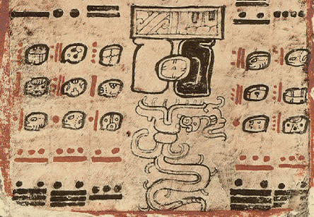
Surviving Maya writing provides the best evidence of astronomy in pre-Hispanic America. Mayan symbols of the sun and the moon are unequivocally known. The 405 lunation eclipse cycle of 11,960 days is known from the Dresden Codex (810 nodal periods = 879 synodic periods or 1.0 : 1.000 010). From Copan Stelae 3 and A, the Metonic eclipse cycle is reported as 6,940 days, equaling 19 solar years and 235 moons. A sequence of bar and dot numerators in the Fejérváry Codex, pages 15 to 22, totaling 6,940 days, one Metonic cycle, was the first notice of this cycle in iconographic texts. The Metonic cycle also appears in the histories of Tilantongo and the Mixteca.
Knowledge of the eclipse cycle is evidenced in the House of the Sun at Palenque, dedicated in A.D. 692. The Palenque ratio is 81 moons to 2,392 days. Maya mathematics employed large integers instead of decimal notation. The 81 to 2392 ratio expresses a value of 29.530864 days per lunar cycle, 0.00028 days less than the present cosmic period. Longer Maya astronomical count intervals accurately equating solar and lunar orbits indicate early astronomical understandings. Evidence of lunar dates begin at A.D. 357 in an inscription from Uaxactun, bearing a Long Count date of 8.16.0.0.0. A vase from Uaxactun places the origin of a lunar calendar prior to A.D. 42.
In the Dresden Codex the Saros cycle was recognized. The most important codex is the Dresden with its eclipse series table. Eclipse prediction infers a certain level of knowledge, including the length of the lunar month, the interval between lunar nodes and the ecliptic limit for solar eclipses. Evidence of eclipse prediction infers this knowledge existed. About 200 lunar observations are known in Maya inscriptions. ....
|
|
| Eclipses, Cosmic Clockwork of the Ancients | Research Results
2009.12.06 - While examining the approximate 345-year eclipse interval known to the Ancient Greeks and Babylonians, one equating 4,267 synodic lunar periods with 4,573 anomalistic periods, I noticed the interval also has accurate integer equation to days and sidereal rotations. Using Epoch v2009, I readily noticed the near solar orbit integer equates 126,352 rotations to 126,007 days, 345 fewer or one day less per orbit. The accurate integer equation of lunar synodic with the apogee-perigee period ensures greater interval constancy of eclipse observations. Each lunar orbit eccentricity period imparts a correlated orbital motion speed change. Comparing eclipse intervals having whole multiples of the apogee-perigee cycle ameliorates the impact of this orbit speed inconstancy. Ancient astronomers utilized this knowledge to determine the appropriate eclipse spans for more accurate mean full moon period determinations. Historically, Hipparchos compared eclipses with Babylonian records from 345 years earlier.
In Table 11, the 345-year eclipse interval compares number of days in integer multiples of six motion periods using 432 B.C. astronomical values (Terrestrial Time). Two accurate integer ratios are with earth sidereal rotations. The most accurate integers interval ratio is moons to days. Use of an eclipse interval which equates to accurate integer rotations and days infers earth motion and time of day and rotation had a role in the eclipse observation interval, likely augmenting the accuracy capability. Accuracy makes this interval a favorable observation choice for those who understand lunar elliptical geometry.
| Table 11. The 345-Year Eclipse Interval |
| Period | Code | Value | Multiple | Days TT |
| Lunar Nodal Period | dn | 27.2122108 | 4,630.5 | 126,006.142 |
| Lunar Synodic Period | dm | 29.53058247 | 4,267 | 126,006.9954 |
| Days | d | 1.0 | 126,007 | 126,007.0 |
| Anomalistic Period | da | 27.5545727 | 4,573 | 126,007.061 |
| Rotations | dr | 0.99726967 | 126,352 | 126,007.0176 |
| Years | dy | 365.2423351 | 345 | 126,008.6056 |
|
126,007 days : 4,267 lunar synodic = 1.0 : 1.000 000 036
126,352 rotations : 126,007 days = 1.0 : 1.000 000 140
126,352 rotations : 4,267 lunar synodic = 1.0 : 1.000 000 176
4,573 anomalistic : 4,267 lunar synodic = 1.0 : 1.000 000 520 |
|
2012.07.25 - Some refinements and corrections to the temporal terms of my astronomy 'constants' formulas has altered the deep decimal expressions and ratio accuracies on this page. Formula details are available in Epoch Calc applet. Conversion to Universal Time will alter the day values.
|
|
| Chavin de Huantar Archaeogeodesy | Astronomy Fundamentals
... Counting in combination with the x - 1 = y geometry theorem solves the astronomy constants conumdrum, a simple solution which evaded archaeoastronomy and went unnoticed by historical astronomy. The same method, using lunar motion, allows resolving other astronomy questions including the rate of precession of earth's axis. The lunar motion metric is 350,000 times more accurate than direct measure of precession (epoch chavin lp = 349,219 lunar orbits per precession cycle). With the 345-year eclipse interval, nearly five days after 345 years, 345 orbits complete and the eclipse of full moon number 4,267 occurs half-a-day before 4,612 lunar orbits complete. The difference between years and orbits is precession quantified and earth rotations, lunar eclipses, and lunar orbits are the metrics.
In the case of precession, the theorem is instead x + 1 = y (Table 2) because the motions are opposing. For example, there is one more eclipse nodal interval than solar orbits per lunar orbit turn. Solving precession resolves the difficult to directly observe period of lunar standstill in relation to lunar orbit turning. ....
| Table 4. Fundamental Astronomy Constants — Epoch Chavin 1200 BCE |
| code | term | UT value |
| lr | lunar orbits per rotation | 0.03650105 |
| ld | lunar orbits per day | 0.03660098 |
| x - 1 = y |
| ro | rotations per orbit | 366.256576 |
| do | days per orbit | 365.256576 |
| lo | lunar orbits per solar orbit | 13.368750 |
| do | moons per solar orbit | 12.368750 |
| tp | lunar orbit turns per precession cycle | 1404.548 |
| sp | lunar standstill periods per precession cycle | 1403.548 |
|
|
|
| Machupicchu Archaeogeodesy | Methods, Coordinates, Precision, and Margins of Error
Precise geodesy is a recent historical achievement. Geodesy as a science measuring the earth has attained the mathematical precision needed to assess if past civilizations measured the earth with precision. New technology makes the ability to determine the latitude and longitude of a monument, be that a petroglyph or a modern property marker, accessible with known accuracy to anyone with a hand held GPS device or even a smart phone. Personal computers with access to satellite imagery displayed by a geograhic information system (GIS) allow determinations of latitude and longitude of any visible feature on the earth. While vastly improved precision in recent decades capacitates this study, margins of error need to be understood in quantifiable terms and must be accounted for in determining confidence in interpretations of data and results.
Accurate determination of ancient monument coordinates can be problematic. Over recent decades it has become much easier with the capacity for precise GPS readings, the world geodetic system (WGS84), online availability of maps and shared photography, and, when precise data is not elsewhere found, GIS tools such as Google Earth (GE). Over time the precision of GE has improved as updates with higher resolution imagery and refined imagery placement increase the area useful for archaeological research.
Geodetic Scale
While analysis of the geodetic relationships of monuments requires coordinate precision to provide confidence in results, the context of the relationship considered impacts confidence immensely. The globe is about 40 million meters in circumference and the arc distance from Machupicchu to Newark Earthworks is nearly six million meters. Thus when considering the location of a monument at Newark in relation to Machupicchu, a GPS datum with plus or minus five meter accuracy has a margin of error of five parts in near six million, about one part in one million. Monuments spaced at great distances from each other offer very high confidence in study results when the margin of error is only one part per million. Likewise, to monumentalize an astronomical constant with mathematical precision, the monuments need to be spaced across vast distances. ...
Tectonic Motion
Another important factor impacts ancient monument coordinate accuracy, the older the construct the greater the monument displacement due to tectonic motion. ... While greater scale of monuument spacing enables greater accuracy in relationship results and higher precision in correlated numerical expressions, with global distances the tectonic motion variable is a factor, and proportionately moreso the more ancient the monuments. Individual site tectonic motion modeling is required to correct coordinates for ancient positions.
|
|
| Machupicchu Archaeogeodesy |
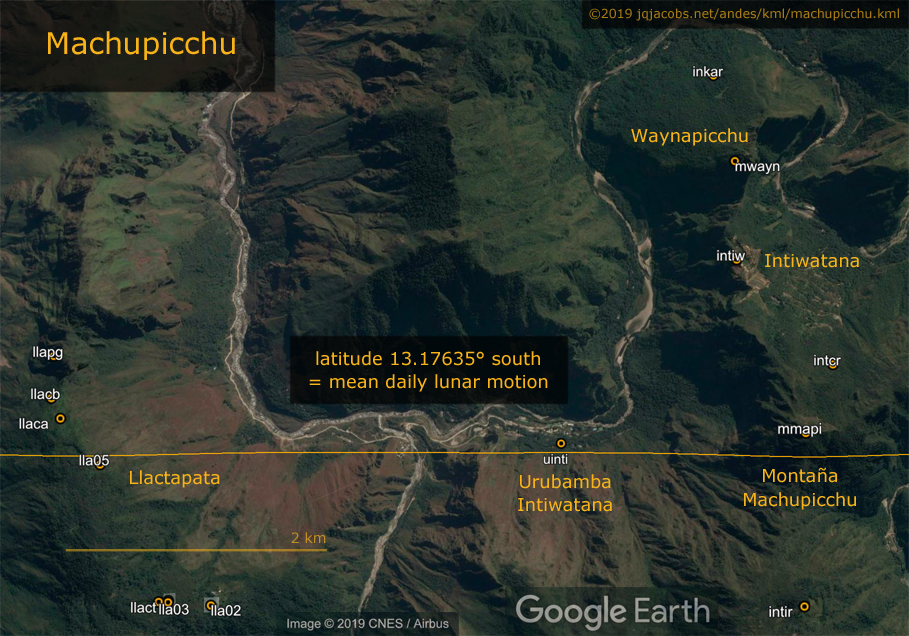
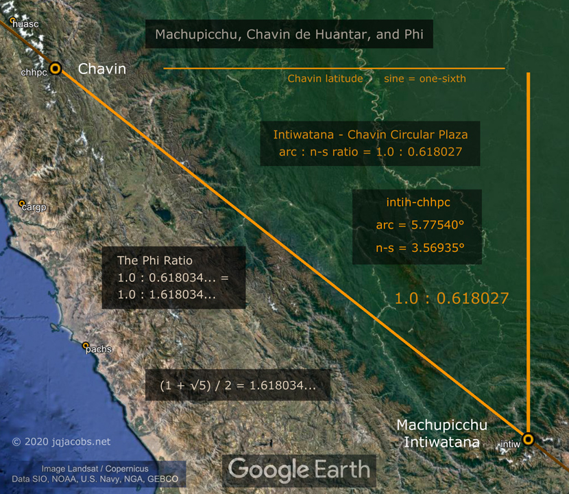
Machupicchu is framed by two lunar orbit baselines, to the north lunar motion per rotation (0.036501 circumference, 13.140376°) and mean daily lunar motion (0.036601 circumference, 13.176352°) to the south near the summit of Montaña Machupicchu and transecting Llactapata ... In other words, Machupicchu is situated between latitudes equating to the circumference of the earth divided by the number of rotations per lunar orbit and the number of days per lunar orbit. This latitude property suggests symbolic positioning, unlike other major monuments situated in relation to a more practical geodetic attribute, the trigonometry of their latitudes ...
... the fundamental 1.0 : 0.036501 ratio of lunar orbits and rotations, the two observable fundamental cosmic motions and the key to quantifying astronomical constants, is a culturally distinct astronomy and the monument relationships indicate Indigenous American astronomers understood heliocentric astronomy and geodesy long ago.
|
|
| Eclipses, Cosmic Clockwork of the Ancients | Mean lunar orbital motion per earth rotation is the fundamental ratio of the counts underlying a sidereal lunar ephemeris and calendar. Accuracy is easily achieved given sufficiently long counting when both counts begin at the same instant, and the longer the count the greater the accuracy. Simply by thinking and counting, ancient astronomers could precisely determine rotations per lunar orbit with naked eye observations.
The orbits of the moon and of the earth are independent motions. The moon orbits the earth in the same direction as the earth orbits the sun, so the earth bound observer sees one less illumination cycle (full moon) than lunar orbits per orbit of the sun. Simply stated, there is one less lunar synodic period per solar orbit because the moon has also circled the sun once.
After each lunar orbit, the sidereal angular position of the sun has changed due to the motion of solar orbit. The lunar phase period is longer than lunar orbit, just as the day is longer than rotation and solar orbit is longer than the year. One moon is longer than one lunar orbit by the inverse of lunar orbits per solar orbit ...
|
|
| |
Latitude Geometry and Astronomy
Latitude is far easier to determine than is longitude. Geodetic latitude is determined using earth's poles and the celestial poles, extensions of the earth's axis of rotation to two fixed, non-moving points in space. To determine geodetic position the local level and plumb reference frame is compared with the angular position of the astronomical pole. The poles inter-reference astronomical and terrestrial coordinates. At Cahokia, the North Pole angle is the arctangent of five-fourths.
The geometry of the angle between the local geodetic and celestial reference frames presents a functional rationale to place astronomical observatories at locations with low-integer geodetic triangles. Monument placement at latitudes where small rational numbers describe the local geometric relationship to celestial motions has astronomical utility. Such placement of observations provides considerable simplification of mathematical operations. With simple integer ratios expressing trigonometric functions, complex math operations are avoided ....
|
|
Sechin Alto is the largest truncated pyramid in the Americas.
At the Sechin monument complex the latitude tangent equals one-sixth.
|
|

| Chavin de Huantar Archaeogeodesy | In archaeology, context is everything. In archaeogeodesy, the entire globe is the geodetic context and monuments the world over are the archaeological context. Context is essential to understanding Chavin, Andean archaeology, and the origins of civilization. Chavin cannot be fully understood without a larger context, the cosmos. Astronomy is as integral to Chavin and many other major monuments as it is to geodesy. Without astronomy you cannot navigate or determine place on the earth.
Chavin, Latitude Geometry, and Astronomy
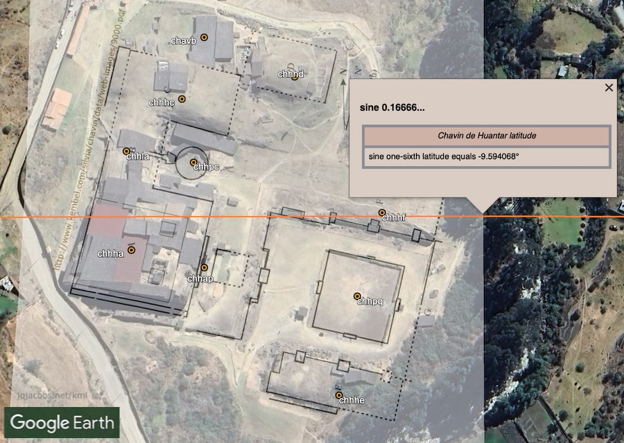
An important astronomic and geodetic context for Chavin is latitude trigonometry. Chavin's latitude sine equals one-sixth (Figure 4). I previously discussed monument positioning at latitudes evidencing accurate astronomy and geodesy in Ancient Monument Latitudes Evidence Accurate Astronomy. The geometry of the angle between the local geodetic and the celestial reference frame presents a functional reason to place astronomical observatories at latitudes forming low-integer geodetic triangles. Monuments with small rational numbers describing local geodetic position have an astronomical practicality, considerable simplification of mathematical operations related to astronomy observations. With simple integer ratios expressing the triangular relationship of place to the axis of rotation and pole, complex and time consuming mathematical operations are reduced while also eliminating inaccuracy of decimal rounding. Additionally, the high elevation at Chavin is advantageous for doing astronomy observations.
Assuming intentional latitude placements, monument positioning manifests the earliest known capability of accurate latitude determination and the earliest known precise astronomical and geodetic measurements. Chavin's precise latitude placement alone implies Chavin was an astronomical observatory. ....
|
|
| Understanding Chavín and the Origins of Andean Civilization | Chavín was once compared to the Olmecs and depicted as the Mother Civilization of the Andes. The term Chavín has been applied to a developmental stage of Andean history, to an archaeological period, to an art style and to a hypothetical empire. Chavín has been interpreted as a culture, a civilization and a religion.
... There are several important areas to consider in assessing the role of Chavín in the origins of Andean civilization. Landscape context is an important aspect of all cultural development trajectories, and particularly so at Chavín. In early Andean communities dependence on more that one life zone promoted interaction, exchange and interdependency, a pattern first evidenced in the coastal valleys where the exchange pattern involved the series of elevation-stacked ecological zones beginning with maritime resources and extending inland to agricultural and pastoral habitats. An excellent example is found in the Casma Valley, at Moxeke, 18 km from the ocean, where almost all animal protein was maritime. Chavín civilization may be the best early expression of a similar pattern on a larger ecological scale, that of interaction between the three major ecological zones, the coast, the highlands and the tropical forests.
Chavín de Huantár, the archaeological site, is uniquely situated in the region of the Callejón de Huaylas, where there are only two ranges in the Andes, rather than the usual three. The glaciated Cordillera Blanca has, in a 180 km long span, a few passes, all over 15,000 feet in elevation. Chavín de Huantár, midway between the coast and the jungle, is located on a route accessing the very extensive Marañon drainage. Almost all the large rivers of the central Andes flow to the Amazon drainage. The Callejón de Huaylas' Santa River drains to the coast, transecting the Cordillera Negra. Via the Santa Valley it is possible to cross the Andes by crossing only one high pass ....
|
|
|
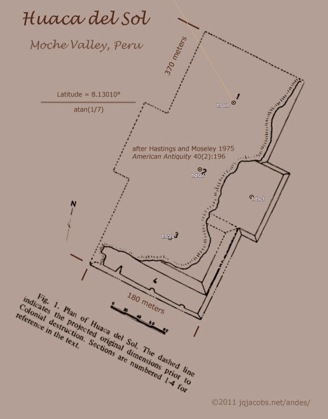
Huaca del Sol, another of the largest New World monuments, is intersected by the arc tangent one-seventh latitude (atan 1/7 = 8.1301°). Huaca del Sol arose along the Rio Moche between 0 and 600 C.E. Most of the Huaca del Sol construction dates from 200 to 400 A.D. Per Hastings and Moseley, "Measuring at least 342 m by more than 159 m, Huaca del Sol was the largest brick structure in South America." Following the Moche era, the Chimor culture built the largest prehistoric city in South America at nearby Chan-Chan.
Most of Huaca del Sol was eroded historically by grave robbers channeling the adjacent Moche river. ....
|
|
| Ancient Monument Latitudes Evidence Accurate Astronomy |
The Neolithic Old World
Complex geodesy was evidenced in the Neolithic before the great pyramids were built at one-tenth of circumference arc distance from older Newgrange in Ireland. Avebury in England (Figure 4) is accurately positioned at the latitude equaling one-seventh of earth's circumference (360/7 equals 51.4285714), double Karnak's latitude. The Avebury complex with the largest megalithic standing stone circle and henge, is located one-one hundredth of the planetary circumference from two major archaeological complexes in Ireland, Newgrange and Tara. The distance from Dowth tumulus to Avebury equals 3.602°, from Knowth to Windmill Hill henge 3.600°, and from Tara Mound to Longstones Long Barrow 3.5999°....
Avebury exemplifies major monument latitude angles subdividing circumference, in this case latitude equals one-seventh of circumference. Further research revealed others. The one-ninth of circumference latitude (40.0°) transects Ankora and nearby the ancient Hittite capital of Hattusha is situated just north of the one-ninth baseline. In Mesopotamia at the Ziggurat of Ur, a known ancient observatory, latitude is a three-to-five triangle (Figure 5). Also in Mesopotamia, the arctangent of three-fourths latitude (36.870°) transects Harran, a major ancient city in Upper Mesopotamia, a center of learning for millenia with known associations to Ur, to astronomy, and, in common with Ur, to the moon in particular. Modern knowledge of trigonometry derives in part from the historical writings by Harran astronomer Al-Battani providing equations for calculating tangents. Thus, a center of learning situated many millenia ago in relation to its trigonometry recently transmitted the knowledge of trigonometry to the West.
In Africa, the arctangent of three-fifths latitude intersects Sais, the very ancient Egyptian capital in the Nile Delta located an astronomically significant distance west of Ur; their east-west difference equals the arc of mean daily lunar motion. The arctangent of three-fourths latitude intersects Carthage in North Africa.....
|
|

| Archaeogeodesy Study Results for Three Major Neolithic Complexes | When obliquity equaled precisely 24 degrees, at Avebury the summer solstice sunset pointed precisely to Newgrange ...
2006.03.09 ... Archaeogeodesy, as a new and developing area of scientific inquiry, illustrates how decisions impacting ancient monuments are made before science develops the tools required to fully study and understand what is being destroyed. The classic example of this dilemna is the burning of the Mayan codices due to religious paradigms; the texts were considered false religion. Today, from three surviving books, the codices are known to be scientific, in fact, the most advanced astronomical texts from that time. From my archaeological viewpoint, an ancient book written on the earth, a geodetic codex, is being destroyed in our time. Our prevailing 'scientific' paradigm is the sum, to a large degree, of beliefs in our time, reflecting ignorance of the past and of the purpose of the Neolithic monuments. What has changed is the scale of the codex being burned ...
A fundamental site variable is geodetic properties of the location. Avebury is today centered at a latitude equaling 1/7th of circumference, 51.428609 degrees. Precisely 360/7 equals 51.4285714 degrees, a slight error still within the henge. From Avebury, at latitude CIR/7, the site-to-site bearing to Tara complex is also CIR/7. Another consideration is local latitude to longitude ratio. Windmill Hill is situated where the equal-degree latitude to longitude ratio is 8:5, or 1.60:1.0. These are not haphazard placements.
From Windmill Hill to Graine Henge, the arc equals one one-hundredth circumference, 3.5885° or 0.009968 CIR. From Windmill Hill to Newgrange the arc equals 3.5886° or 0.009968 CIR. The arc distances between the Irish and British site features considered herein ranges from 3.576° (Windmill Hill to Dowth) to 3.608° (Avebury to Newgrange). In fractions of circumference, the range is from CIR/99.77 to CIR/100.66.
|
|

| The Ur and Harran Latitudes, and Göbekli Tepe | NEWS: "... latitude at Harran equals 3/4 atan and at Ur 3/5 atan ..."
2008.04.25 ... ... Harran is renowned as a Sabaean center associated with a moon "temple" and as an earlier Sumerian center. Harran was an important, once-populous prehistoric crossroad. I noticed Harran's latitude is 36.87 degrees, the acute angle of a 3:4:5 geodetic triangle (3/4 arctangent = 36.8699°). Was knowledge of the latitude considered in locating a moon temple at Harran? When is a "moon temple" an observatory? When is idolatry exact science? ...
The history/myth of Mesopotamia holds that Ur and Harran are two important, related Sumerian centers, both associated with the moon ...
Summarizing, colatitude at Harran equals 4/3 atan and at Ur 5/3 atan. Thus, latitude at Harran equals 3/4 atan and at Ur 3/5 atan ...
... if I must, I might argue the Ur and Harran "moon temples" evidence a relationship to astronomy and precise knowledge of geodesy. In other words, what we call exact sciences ....
|
|
| Ancient Monument Latitudes Evidence Accurate Astronomy | |
Ancient America
Cahokia was a late expression of monumentality in the Americas. Early monuments in Peru are contemporaries of the European Neolithic and the early civilizations in Egypt and Sumeria. Recent radiocarbon dating revealed surprisingly deep roots of civilization in the river valley oases of the Andean coast. Aspero, a large early center with platform mounds, has 4,800 to 5,000 years before present carbon fourteen dates from late phase construction. In the Americas, mound construction starts at an early date, well before the pyramids of Egypt were constructed. Watson Brake in northern Louisiana, dated from 5,400 to about 5,000 years ago, is one of the oldest-known, large-scale mound sites in North America.
During the chronology of American civilizations, some of the largest of monuments were built precisely at latitudes with integral geodetic triangles. The Casma-Sechin Valley contains the largest concentration of Preceramic period, Initial period and Early horizon sites along the Peruvian coast. The large concentration of Initial period (1800 B.C. to 900 B.C.) Casma-Sechin monuments is located in the lower valley where the alluvial plain widens and good, irrigable land is found. The largest of the Casma-Sechin sites is Sechín Alto with a U-shaped monument plan covering about 200 ha. The baseline where latitude tangent equals one-sixth transects the Sechin Alto complex ....
The Sechin Alto U-shaped complex, the largest monument in a monument-filled district, spans the broad valley. The same baseline, the arctangent of one-sixth (atan 1/6 = –9.4623°), also crosses the Sechin Bajo complex west of Sechin Alto. Just to the north lies Taukachi-Konkan. To the south in the Casma branch of the valley, Huaca Moxeke and Huaca Pampa de Las Llamas form another immense U-shaped complex. Due south is Chankillo, a complex hypothetically associated with astronomy. Just north of Chankillo, latitude equals one-sixth radian. South of Chankillo lies the latitude with sine equaling one-sixth (asin 1/6 = 9.5941°), which intersects a major archaeological complex in the Andes, Chavín de Huantár ....
|
|
| Reflections on Prehistory essays written in 1995. | Early South American Civilization
The ecologically varied Andes and adjoining terrain produced a unique emergence of civilizations at an early date. A pre-agrarian, pre-ceramic adaptation to rich, easily accessible maritime resources coupled with a vertical adaptation to nearby stacked mountain resource zones enabled very early sedentary communities to develop along the 600 kilometer stretch of northern Peru's coast coincident with the continent's and one of the world's richest fisheries. In the oases of the numerous coastal valleys formed where Andean rivers transect the arid desert, pre-ceramic populations expanded to thirty times the Lithic (15,000 to 5,000 BP) Period levels. Village populations grew to 1,000 to 3,000 persons and large monumental architecture developed. Contemporaneous to the construction of pyramids in Egypt and ziggurats in Mesopotamia, small Peruvian coastal communities cyclically renovated ever larger pyramidal platform mounds that framed large, open plazas with circular sunken courts. Sites generally consisted of two or more different sized platforms surmounted with buildings. Aspero, a large early center with six major platforms, has 4800 to 5000 BP. carbon 14 dates from late phase construction. El Paraiso, the largest and most extensive pre-ceramic monument complex in the Americas, includes nine masonry platform constructs in a U shape framing a seven hectare plaza. This first nucleated settlement occupied 58 hectares ....
|
|
| Chavin de Huantar Archaeogeodesy | Chavin and the Origins of Civilization
... Where and when did ancient geodesy originate?
How to arrive at a satisfactory answer is a challenging puzzle? The relationships of monuments and mountains provides a deductive tool, mountains came first. Huascaran, Aconcagua, Illimani, Salkantay, Denali, Cerro Machu Picchu, et.al., all are fixed points, enduring geodetic references. Contrastingly, many points share the latitude of Chavin, or Sechin and others, offering flexibility in placements at specific latitudes. Dating of archaeological sites also frames questions with differing threshold dates. Site origin may be older than a monumental construct, but at least dating a monument provides a specific time depth, a minimum age for a placemark.
... Along with mountain positions, certain givens can foreclose other possibilities. Mountains with results in relation to Giza, Chavin, and major sites may restrict the plausible sequence of monuments—after all the mountains precede the monuments.
... Andean mountain peaks are a foundation for key monument placements. The mountains contextualize the question of where and when ancient geodesy originated. The challenging puzzle of the origins of ancient geodesy and advanced civilization brings very different and surprising perspectives to current understandings of archaeology and the unity of past civilizations. The monuments and mountains taken together continue to provide surprising answers to "Where and when did ancient geodesy originate?" ....
|
|
| Reflections on Prehistory essays written in 1995. | Early North American Civilizations
The Olmec horizon, the first in North America to evidence the complexities associated with civilization and organized polities, is known from Mesoamerica and concentrated around the southern Gulf of Mexico. Olmec cultural attributes include a mound-plaza-stelae complex, calendar conventions, and glyphic writing with both iconographic and stylistic symbolic components. Megalithic sculpted solid rectangular monoliths and massive stone heads (hallmarks of the Olmec) adorned their mound complexes. Dated from 3500 to 2900 BP., San Lorenzo, an extensive earthen mound complex, is the oldest of the Olmec centers. La Venta follows in chronological sequence with radio-carbon dates from 2900 to 2400 BP. Basalt for the megalithic La Venta sculptures was transported sixty miles from the Tuxtla mountains. Tres Zapotes followed La Venta as the principal Olmec center. These Olmec centers had very similar site orientations and reflect overall planning and design, possibly extending to regional considerations ...
History and prehistory are multidimensional, having spatial and temporal dimensions. In the case of prehistory the planet is minuscule relative to the time dimension. Even the average person's life is very long relative to the amount of time required to canoe, for example, from the Yellowstone headwaters to the upper reaches of the Amazon drainage. With this view in mind there should be little doubt that long distance interaction and diffusion was possible even if exceedingly infrequent. If there is a connection or remote common antecedent to the use of similar mound complexes careful research and study of these features should reveal that interconnectedness.
Such a study can begin with the spatial interrelationships ....
|
|

| Ancient Earthworks of Eastern North America | The Archaeological Context of the Earthworks
Monuments mark the rise of civilizations world-wide. The earthen mounds of Eastern North America are part of a long-standing monument tradition. In the Americas, mound construction starts at an early date, well before the pyramids of Egypt were constructed. Watson Brake in northern Louisiana, dated from 5400 to ca. 5000 BP, is one of the oldest-known, large-scale mound sites in North America. Watson Brake's dating placed mound construction in the Mississippi Valley at near 2,000 years before well-known Poverty Point, previously thought to be the earliest mound site in the United States. Watson Brake consists of an oval formation of 11 mounds from three to 25 feet tall connected by ridges to form an oval near 900 feet across. With Watson Brake's discovery and dating, pre-agricultural, pre-ceramic American societies were shown to be more complex than previously thought.
The oldest civilization in the Americas arose along the Pacific Coast of the Central Andes, where mound construction began by 5,100 years ago ...
For thousands of years, North, Central, and South American monumental complexes arose and grew. The earthworks in Eastern North America represent a long chronology of cultures creating monuments. The rich record of earthen constructions equates to many thousands of years of history, spanning from Watson Brake and Poverty Point to large Adena mounds, to the Hopewell culture's florescence of geometic works, to numerous, diverse expressions, and to Monks Mound and the many mounds of Cahokia—the culmination in size of both earthen construction and settlement in prehistoric Eastern North America.
....
|
|
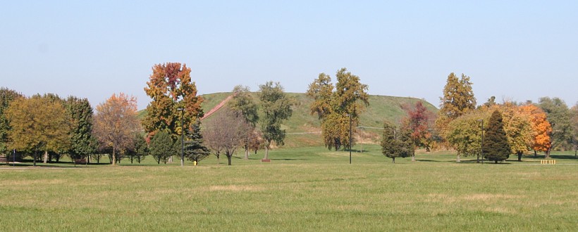
| Mesoamerican Archaeoastronomy | The Mesoamerican civilizations constructed numerous administrative and ceremonial centers and erected numerous monuments. These reflect astronomical knowledge and expertise in numeration and calendrics ...
One of the primary resources for study of Maya astronomy is the epigraphic record in four Mayan codices containing hieroglyphic writings that survived the widespread Spanish book burnings of the conquest period. The rediscovery of these volumes in European libraries in the mid-nineteenth century marks the beginning of modern inquiry into the intellectual achievements of the Maya. Post conquest writings depicting calendrical cycles and numeration played a role in the decipherment of Maya script ...
... the prehistoric civilizations of Mesoamerica had advanced astronomical knowledge relative to their contemporaries in other parts of the world ...
I began this research with the view that the astronomy of Mesoamerica was not precise, perhaps in part due to the influences of many previous writers ... Testing the accuracy of just several dates and time spans, using astronomic variables commensurate with the dates under consideration instead of comparing Mesoamerican astronomic values to present day quantities, has led me to conclude that the accuracy of Mesoamerican astronomy may have been precise. ....
|
|
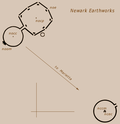
| Newark Octagon Earthworks, a Photo Gallery | One of the most significant traces of ancient civilization in Eastern North America is the complex array of geometric works arrayed on the earth, the greatest concentration of which covered several square miles at Newark, Ohio. The Newark Octagon, the most northwestern of the earthworks at Newark is the largest of all geometric earthworks. The contiguous earthwork of Observatory Mound, Observatory Circle, the parallel embankments, and the Octagon combine to extend 2,898 feet.
... Excerpts from my 2001 paper Possible Geodetic Properties and Relationships of Some Monumental Earthworks in the Middle Ohio Valley, A Preliminary Inquiry.
The relationships between Newark Earthworks and Marietta Square and the orientations and relationships of the various monuments of Newark Earthworks offer the best evidence of knowledge and practice of geodesy. The Newark Octagon and Marietta Square ratio of arc distance to longitude difference, the azimuth of the Newark Octagon, and the bearings between Newark Circle and the Octagon Circle infer precise understanding of the mathematical ratio of latitude to longitude. The precise commensuration of the Newark to Marietta arc distance and their longitude difference with the SO module (earth’s angular orbital motion per day) infers a precise understanding of astronomic constants and the scale of the earth. The redundancy of expression of the same relationships makes it very difficult to discount the relationships as coincidental. ... The fact that the largest of the monuments express these geodetic relationships also argues against coincidence. Given the distances involved, creating the relationships between the Middle Ohio monuments could have been accomplished using direct surveying and mathematics ...
... the builders of the Middle Ohio earthworks understood aspects of geodesy, including accurate astronomical knowledge, knowledge of the scale and shape of the earth, knowledge of their location on the earth, and how to place find and point position.
|
|
| ArchaeoBlog by JQ Jacobs: Page 3 | Oct. 27, 2005 - ... The first residents of Marietta did preserve some of the unique works, so we have to give them some credit. They passed a resolution making the squares commons areas.
We can literally read these sites. They speak volumes, a bit of which I hope comes through in my writing. They are a codex, written on the earth. Even the context has meaning. ... the monument builders are still speaking to all people for all time forward. It is we who cannot read or hear or see, who lack feeling for what the ancients have given us. Destruction of ancient monuments is no different than burning libraries. Each time another mound or ruin is destroyed, another word is erased from the grandest codex ever created, a book as large as the earth itself and intended to last for all time. ....
|
|
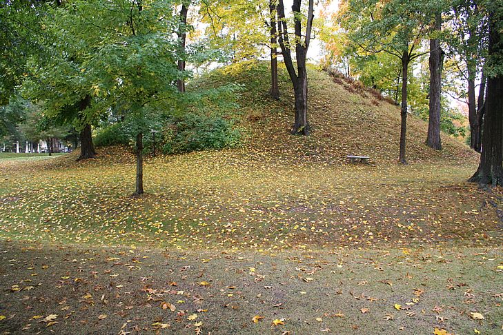
| The Ancient Works at Marietta, Ohio | "Within the larger enclosure are four elevated squares or truncated pyramids of earth, which, from their resemblance to similar erections in Mexico and Central America, merit a particular notice. ... Three of these have graded passages or avenues of ascent to their tops. The principal one ... is one hundred and eighty-eight feet long by one hundred and thirty-two wide, and ten high. Midway upon each of its sides are graded ascents, rendering easy the passage to its top. These grades are twenty-five feet wide and sixty feet long ...." Squier and Davis
|
|
Newark Archaeogeodesy
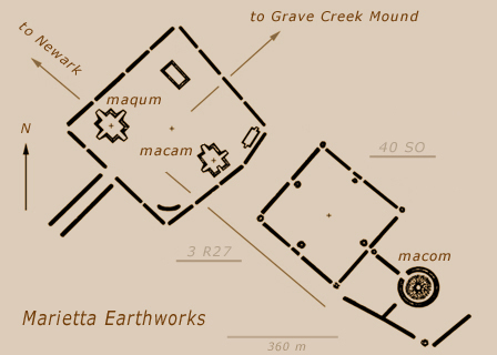
Assessing Evidence of Geospatial Intelligence in the Americas | 2009.01.09 - ... I took a great leap forward in methods in 2005, traveling to Ohio for GPS readings on the mounds, then confirming the GPS positions in Google Earth. ...
Marietta latitude ... presents a low integer ratio for rotations and lunar orbits. Latitude baselines transecting the site equal both 40 times solar orbit per day ... and three times lunar orbit per rotation ... Around 322 A.D. earth's rotation axis was inclined 3/5th's of Marietta's latitude, an arc equal to 1.8 r27 and 24 days of solar orbit ....
Reflections
2009.04.05 - The degree of geospatial intelligence in the ancient Americas was certainly greater than historically known. The sophistication of ancient geodesy and astronomy in prehistory transcends current paradigms in archaeology. Well, reality is transcendental, independent of thought about it. Ignorance of the past not equating to a past of ignorance is no surprise. Geospatial intelligence in the ancient world was apparently far greater than documented by current historians.
The telescope is no substitute for counting and thinking. Fortunately for archaeology, the mathematics of astronomy and geodesy transcends cultural and temporal boundaries, remaining accessible and assessable without ancient oral languages. As incontrovertible as the actuality of arc distances and astronomical constants may be, intentionality must be addressed. Incontrovertibly demonstrating intentionality is a more difficult thresold than empirical analysis of geometry. Fortunately also, the sheer size of the earth is a very large scale, an incontrovertibly robust control with contextual geodetic meanings permitting precise knowledge expression and refined quantitative analyses.
Paradigms in science, while resistant to alterations, do crumble even if slowly in the face of incontrovertible evidence. At least mine have. Lost history is not what it once was.
|
|
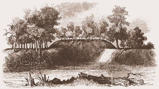
Observatory Mound and Observatory Circle, Newark Octagon Work |
Newark Archaeogeodesy
Assessing Evidence of Geospatial Intelligence in the Americas | Calendar keepers count days and years, or rotations, or moons. Astronomers count all these and more. Three fundamental astronomical motions, earth rotation and lunar and solar orbits, present the following ratios in integers; there are 10,000 rotations in 365 lunar orbits and in 366 there are 10,000 days. The two lunar orbit numbers, 365 and 366, are repeated in the Octagon to Marietta arcs, with Octagon-Quadranau arc equaling cir/366 and Octagon-Capitolium equaling both cir/365 and E-W cir/365 ...
| Table 1. Newark and Marietta Arcs |
| arc | arc | e-w |
| Octagon - Capitolium | 0.9863° = cir / 365.0 | 0.9864° |
| Octagon - Quadranau | 0.9837° = cir / 366.0 | 0.9832° |
| lunar constant values | module |
| lunar orbits per rotation | r27 = 13.140381° = 0.036501 cir |
| lunar orbits per day | c27 = 13.176357° = 0.036601 cir |
|
|
| Cahokia Mounds Photo Gallery | Monks Mound, the largest prehistoric monument north of Mexico, is also the largest-in-volume prehistoric earthen construction in the Americas.
... Monks Mound may have been positioned with a predetermined geodetic attribute, the latitude tangent equals 0.80 (Monks Mound's geodetic axis is the hypotenuse of a 4:5 triangle). ... The latitude where tangent equals precisely 0.80 is 38.65981 degrees. Today atop Monks Mound the latitude, GPS mean of four corner readings of upper terraces, equals 38.66052 degrees N. (tan = 0.800020).
|
|

| Ancient Monument Latitudes Evidence Accurate Astronomy | Accuracy
Ancient Egyptians aligned the Giza pyramids to north. Spence (2000) writes they are "oriented to the cardinal points with extraordinary precision." The polar orientation of Khufu's Pyramid (the Great Pyramid) deviates by less than 3 minutes of arc (one part in 1,146 of its 230m base dimension), demonstrating accurate astronomy and surveying. Spence concluded circumpolar stars were employed to align the pyramids. In Egyptian writing, 'stretching of the cord' and surveying is well recorded and astronomical alignment of monuments is well known. Intentionality of the cardinal alignment of Khufu's pyramid is reasonably accepted.
The size of the pyramid provides an extraordinary opportunity to determine ancient accuracy of determining north. However, latitude positioning of monuments in relation to the enormous scale of the earth offers a much more refined assessment of the precision of ancient astronomy. Latitude positioning encompasses the circumference of the earth, a ruler over 40 million meters long in comparison. One millionth the distance from pole to equator is just over 10 meters. The scale of the Great Pyramid, 230.3m long, is just one part in 174,000 of circumference.
|
|
| 2018 ArchaeoBlog | Amazon Archaeology
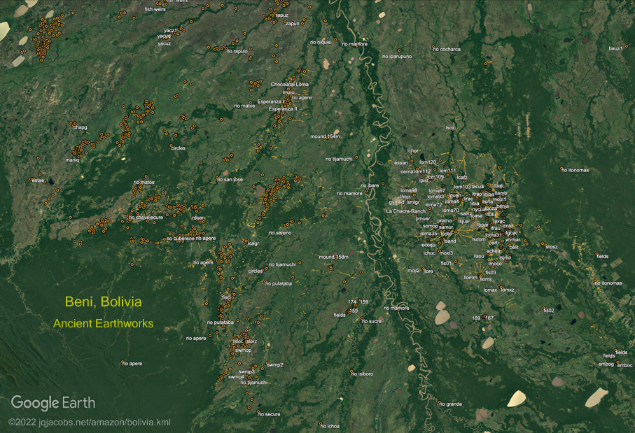
2018.01.06 - Celebrating 25 years of archaeogeodesy and a decade of space archaeology continues with release of more Google Earth files. During the past two years high resolution satellite imagery updates enabled more surveys in the Amazon. Coverage includes the tierra firme geoglyphs region in Brazil, Bolivia, and Peru, and the Llanos de Mojos in Bolivia including the Monumental Mounds Region in SE Beni. The Llanos de Mojos, the immense seasonal flood plains in the Bolivian Amazon, is noteworthy for the amount of earthmoving visible in satellite imagery.
Previously unknown, immense ancient monuments are now visible and reported. Given coverage voids still remain in my survey of the region, more surprise discoveries may follow ....
|
|
| 2022 ArchaeoBlog |
2022.01.01 ... Last month I commemorated my fiftieth anniversary of completing Peace Corps service in Peru and moving to Oregon. Living in Peru including very briefly in the Machupicchu ruins, after training in Mexico and experiencing Mexico's amazing National Museum of Anthropology, led to my interest in and study of archaeology. Half a century later as I focus on specific regions, I'm still discovering how incomplete even my own understanding of the vastness of the archaeological record is ... just surfing the Web Archive photographers of neolithic ruins made me realize how incomplete my understanding of the sheer number of menhirs was.
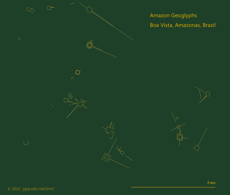
Returning to the Amazon virtually, surveying and resurveying higher resolution satellite imagery had the same effect, impressing me with how my own awareness falls so far short of what is actually out there. In the last few years my Amazon Geoglyphs KML file has grown from over 500 to over 1,100 monuments. I was repeatedly surprised to find truly immense monumental earthworks which have gotten almost no attention if any at all. I also plainly see landowners destroying these wondrous archaeological monuments for the sake of their own convenience exploiting the colonized Native lands ...
I am also perceiving how quickly Amazon deforestation progresses. I noted how much difference just a few years has made in areas I resurveyed, so I zoomed out in Google Earth Pro and used the Historical Imagery tool to go back in time year by year to 1985 before deforestation, when the geoglyphs were still hidden under the trees, quite undiscovered by archaeology. On a macro scale, the before and after images drive home the degree to which the planet is being altered by humans. Is our understanding of the impact we have on the ecosystem complete enough to avoid a catatrophic collapse? ... The more we learn, the more we realize how little we know, and that can be a discomforting awareness. The sum of many individuals acting in self interest can be very destructive on a larger scale. The Amazon today is not the same place I left 50 years ago.
|
|
| 2021 ArchaeoBlog | Amazon Geoglyphs Update
2021.12.30 - After nearly three years, I've taken time to catch up on geoglyph surveying and updating my Hundreds of Geoglyphs Discovered in the Amazon webpage. I would have chosen a different title a decade ago if I'd foreseen this update includes 1,100 plus geoglyphs, zanjas, and mound villages. Each year the number grows, and this doubles my three years ago number. With new satellite imagery online more earthworks are revealed as a consequence of better resolution, land clearing, sometimes due to overgrazing, often due to deforestation, and even because of seasonal vegetation differences. And, while I have resurveyed most areas, there are areas with geoglyphs I still have not fully surveyed ...
Recent field research and journal articles have expanded knowledge of the earthworks. A lidar survey revealed new details of mound villages and roads. Google Earth enables appreciation of the vastness of this archaeological expression and the vast quantity of monumental earthworks, and it allows geolocating the knowledge. Archaeologists on the ground, or in helicopters today, bring details of the past to light. This update features new placemark balloons with quotations and links to pertinent publications, attaching the information to the places investigated. The references folder is updated in the webpage and now also included in a placemarks folder. Videos are linked in the references and more are embedded in the webpage. Photography is an essential aspect of appreciating the scale of the geoglyphs and human effort they evidence. More links in the webpage lead to some great new online photos ....
|
|
| 2023 ArchaeoBlog | Amazon Geoglyphs
2023.02.04 ... We will know the full extent of the archaeology once the region has complete lidar surveying, given of course, if the evidence is not plowed away. Too often resurvey also reveals illegal earthwork destruction in recent years.
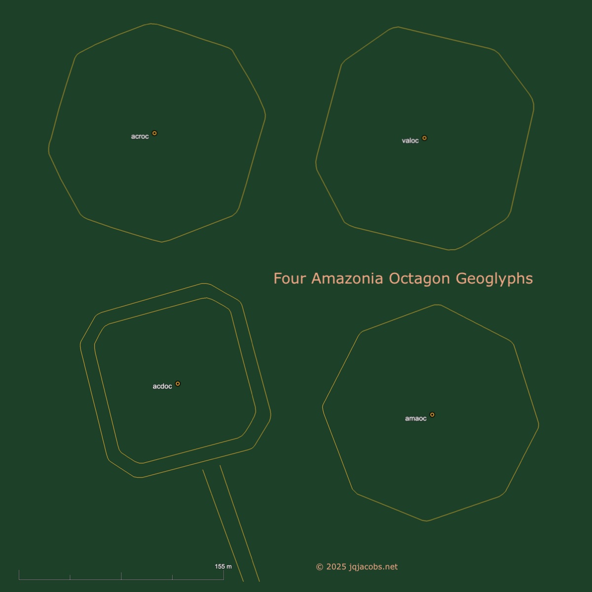
One earthworks recently impacted by illegal destruction is a very unique geoglyph, one I dubbed the Acre Octagon. So far it is the only known octagon geoglyph* in the Amazon, which alone makes it a significant cultural treasure. I first placemarked the site in 2010, before the destruction. The 2010.06.30 Google Earth satellite image clearly shows the 150-meter-wide outline in a pasture, revealed after destruction of the forest. Illegal damage by agricultural plowing is evident in the 2016 satellite image.
I wish I had examined the relationship of the Acre Octagon to Newark Octagon a decade earlier ... in May of 2022, when I finally examined the spatial relationship of the Acre Octagon with Newark Octagon, did I note the cosine of their arc distance equals phi. Perhaps earlier discovery and publishing of this knowledge could have averted the plowing of the geoglyph. ... I also noticed Acre Octagon is twice as far from the North Pole as Newark Octagon ....
|
* I have since remaned a previously recorded geoglyph as Acre Double Octagon, so Acre Octagon was actually the second of now four octagon geoglyphs I have recorded in Amazonia.
|
|
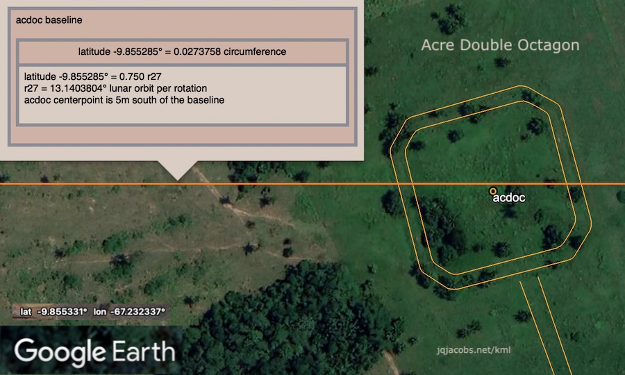
Newark Archaeogeodesy
Assessing Evidence of Geospatial Intelligence in the Americas | |
Newark Earthworks and Mountains
2024.01.20 - The highest mountains in the Americas are prominent in my research results. Mountains predate monuments and are excellent natural geodetic reference points. Mountain peaks may become altered over time or volcanic eruptions can obliterate them, but unlike the geodetic poles they are fixed positions in relation to their surrounding landscapes. Noting geodetic relationships between mountains and human monuments presents the obvious question, intentionality. Redundancy combined with precision within a few parts per million supports interpretions of intentionality.
... the Octagon to Capitolium arc of 0.9863° equals 1/365.0 of circumference of the earth. The arc of mean lunar orbit per rotation, the singular readily observable ratio of the fundamental cosmic motions, equals 0.036501 circumference. Denali, the highest point in North America, the Octagon, and the Capitolium express a north-south ratio of 1.0 : 36.50274 at the Octagon centerpoint. Capitolium latitude is three times 0.0365040 circumference and Conus Mound three times 0.0365003. Observatory Circle, High Bank Circle, and Aconcagua, the highest peak above sea level in the Americas, have an east-west ratio of 1.0 : 0.036509 at High Bank. At the immense, 480-meters-long Amazon Oval geoglyph, the ratio of arc distance to the Great Circle and to Chimborazo, earth's highest point above geodetic center, equals 1.0 : 3.650107, a precise expression albeit with decimal shift ....
Eagle Mound - Caracol - Tumi Chucua Zanja
e-w ratio @ carac = 1.0 : 3.650067 (+7m)
Octagon Earthwork - Tikal Acropolis - Aconcagua GPS
e-w ratio @ tikac = 1.0 : 0.366012 (+5m)
Observatory Circle - Llactapata Group B - Aconcagua GPS
n-s ratio @ llacb = 1.0 : 0.366008 (-8m)
Newark Earthworks and Amazon Geoglyphs
2024.01.22 - Amazon geoglyphs became a significant focus for me because the geometric earthworks, the circles, squares, ellipses, ovals, and even an octagon, resemble Hopewell earthworks and also because I could not ignore these immense constructs while assessing the origins of monumentality, especially when considering if some monuments determine where other placemarks are positioned, if a chronology is detectable. Since 2010 I've posted results of my satellite imagery surveys and research online in Hundreds of Geoglyphs Discovered in the Amazon.
... I recently saw a zoom lecture with an archaeologist claiming longitude determination wasn't possible in prehistory because the British had not developed accurate clocks yet. I had to point out that land based placemarks are not floating about on an ocean, that time is known at fixed positions, and that coordinate accuracy can be resolved by observations over a long temporal span. On a ship in the ocean two equation unknowns, time and place, complicate solving the question, "Where are we?" Determination of longitude from stationary points is a distinct problem, more so with the added dimension of time providing centuries to refine precision.
....
|
|
| Hundreds of Geoglyphs Discovered in the Amazon | 2025.07.29 - New 2025 high resolution satellite imagery updates have been surveyed and files updated, adding forty geoglyphs. The new satellite imagery revealed nine more geoglyphs plowed, damaged, and/or destroyed.
2025.04.12 - Now more than 1,550 geoglyphs, zanjas, and mound villages are recorded in the Excel database and the KML placemarks file linked above. The 2024 high resolution satellite imagery updates in the core geoglyphs region were mostly taken during the season of optimal vegetation contrast, revealing improved detail. The recent publication of another database also contributed to the additions ...
The improved resolution of the 2024 satellite imagery with optimal season vegetation contrast revealed more embankment (terraplen) geoglyphs, earthworks without ditches (zanjas), and roadway berms leading to the enclosures. These geoglyphs are not as easily detected in satellite imagery and also more susceptible to destruction. Some of these geoglyphs in the updated satellite imagery were already destroyed by agricultural plowing before they were discovered, including one of the very largest oval monuments ....
|
|

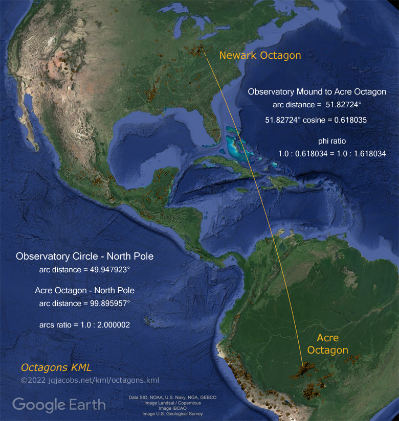
|
Phi, Φ, 1.618034..., an irrational number like pi, is the solution
to a quadratic equation with unique mathematical properties. | |
One plus the square root of 5 divided by 2 | (1 + √5) / 2 = 1.618034... = Phi |
| One minus the square root of 5 divided by 2 | (1 – √5) / 2 = -0.618034... = negative phi |
Square Phi and the result is exactly one greater, 2.618...,
Divide Phi into 1 and the result is exactly 1 less, phi = 0.618.... |
|
| 2024 ArchaeoBlog | 2024.10.19 - This past summer Google Earth updated satellite imagery in much of the core Amazon geoglyphs region with high quality imagery taken during the optimal season, plus a new database online followed. So far this year I've added several hundred geometric earthworks to my database and placemarks files and I've updated the relevant files linked below.
I rate as the most interesting find another octagon geoglyph, not only the same size as the Acre Octagon but the newly dubbed Amazonas Octagon also has a correlating geodetic relationship to Newark Octagon ... The Newark to Acre Octagon arc distance has a cosine value of phi and the Acre Octagon is twice as far from the north pole. Newark and the Amazonas Octagon express the phi ratio with colatitudes, their respective distances to the north and south poles.
|
|
|
Golden Mean Longitude Ratios
Stated simply, the golden mean or golden ratio divides a line such that the whole is proportional to the longer part as the longer part is to the shorter part. The formula x : 1 = 1 : x + 1, stated numerically is 0.618034. : 1.0 = 1.0 : 1.618034, where Phi like pi is an infinite irrational number (1.6180339887...). Upper case Phi is 1.618... and lower case phi is 0.618..., Phi - 1 = phi.
|
|
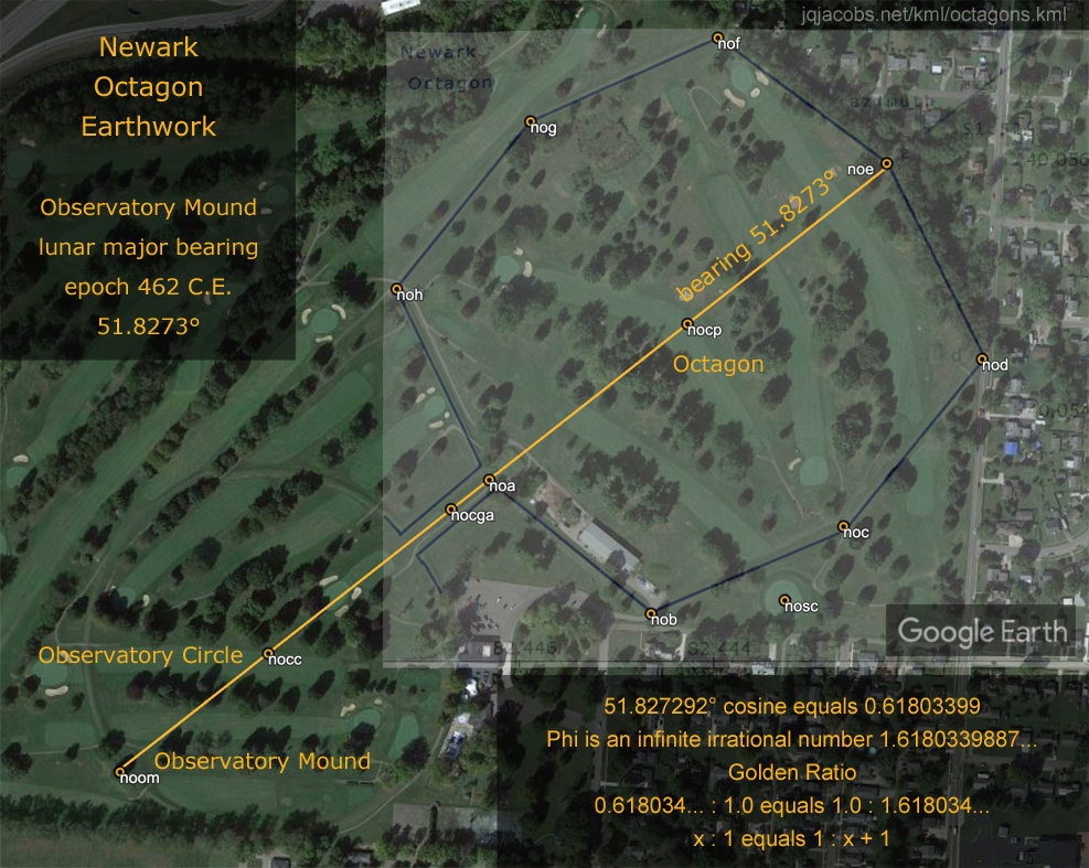
| Phi ratio 1.0 : 0.618034... = 1.618034... : 1.0 |
Observatory Mound - Acre Octagon
arc 51.827238° cosine = 0.618035 (-6m)
Machupicchu High Group - Huaca de la Luna
latitude ratio = 1.0 : 0.618034 (+1m)
Waynapicchu - Huaca del Sol baseline
latitude ratio = 1.0 : 0.618033 (-1m)
Waynapicchu - Huaca del Sol baseline - Huayna Potosi
n-s ratio @ mwayn = 1.0 : 0.618036 (+2m)
Huaca del Sol baseline - Huayna Potosi
latitude ratio = 1.0 : 0.500000
Great Circle - High Bank Works - Seip Mound GPS
e-w ratio @ ncec = 1.0 : 0.618035 (+0.1m)
e-w ratio @ hibaw = 1.0 : 0.618035 (-0.2m)
e-w ratio @ seipm = 1.0 : 2.618044 (-0.1m)
Newark Octagon - Rattlesnake Mound - San Lorenzo
e-w ratio @ nocp = 1.0 : 0.618038 (+6m)
Aguada Fenix - Chimborazo GPS - Aconcagua GPS
n-s ratio @ acong = 1.0 : 0.618033 (-6m)
Tumi Chucua Zanja - Apu Illimani GPS - Pumasillo
n-s ratio @ ailli = 1.0 : 0.618033 (-1m)
|
|


| Machupicchu Archaeogeodesy | Lunar Standstills and Lunar Orbit Inclination
... major sites and Machupicchu have interrelationships expressing pi, phi, astronomy constants, and astrogeodetic modules. The mathematical expressions are often the spatial relationship of three monuments and the same proportions are expressed redundantly by various combinations of and different geometric relationships of the same major monuments. I find these to be strikingly impressive achievements of not only nesting the monumental arrangement on a spherical earth but also of both understanding fundamental cosmic motions and accurately determining the corresponding astronomical constant values.
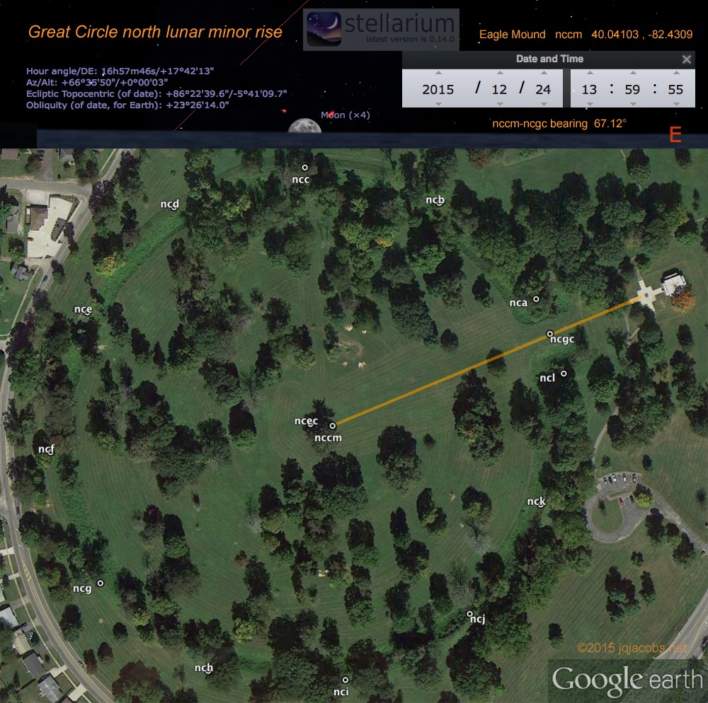
Western cultural astronomy is focused on the apparent 18.613 year lunar standstill period of the varying angular span of moonrises and moonsets on the horizon. Lunar orbit inclination turning is the sidereal cycle producing this apparent lunar motion period and the predominant constant of these two as expressed by the monuments. This precessing motion, lunar orbit inclination turning, slowly gyrates the intersection of lunar orbit and the ecliptic and consequently where eclipses occur in relation to fixed space. Lunar node retrograde rotation around the ecliptic equals 18.5990 solar orbits. Ancient monuments precisely evidencing both, the 18.5990 orbits sidereal cycle and the 18.613 year apparent motion period (Table 3), imply advanced understanding of lunar motions and another precession motion, the also gyrating orientation of eath's axis of inclination caused by lunar motion. Precession of the rotation axis inclination produces the difference between the sidereal cycle (ot) and the lunar standsill period (os).
| Table 3. The Lunar Major Constants |
| code | values | constant |
| ot | 18.5989996 | orbits per lunar orbit turn |
| et | 19.5989996 | eclipse nodal intervals per lunar orbit turn |
| yt | 18.5997194 | years per lunar orbit turn |
| os | 18.6123968 | orbits per lunar standstill period |
| ys | 18.6131171 | years per lunar standstill period |
| es | 19.6131171 | eclipse nodal intervals per standstill period |
|
|

| Newark Earthworks, the Great Circle Photo Gallery | ... The Newark array of circles, a square, an octagon, parallel embankments and circular and elliptical mounds was the most diverse, extensive and complex of earthen monument sites.
... The Great Circle has the highest of the embankments at Newark. Based on survey, in this section of the "Newark Works," Whittlesey, Squier, and Davis (1837-47) reported nine feet high and 45 feet wide at their base embankments surrounding the seven feet deep and 35 feet wide ditch. They reported the entrance is emphasized with 16 foot high embankments above a 13 foot ditch.
... With summer vegetation, the views across the full breadth of the Great Circle are fleeting few. From the northern arc's embankment, the group of four co-joined mounds at the center of the circle (Eagle Mound) are discernible as small rises of earth. The mound form, variously described as an arrow, or a bird, or just co-joined mounds, covers the remains of a large ancient structure, as do some other mounds in the region. The arrow-form layout of the four distinct hummocks pointing to the entrance is noteworthy. ....
|
|
| Newark Earthworks and Pinson Circle | 2016.04.16 - Newark Earthworks is monumental, an outlier in scale of constuction. Archaeogeodesy research results confirm its prominence. Pinson Mounds in western Tennessee, the largest Middle Woodland mound complex in the Southeast, includes the second-highest mound in the United States. At 160 acres in extent, Pinson is larger than the Ohio earthworks complexes with the exception of Newark. In scale, Pinson Circle is equal to Newark's slightly elliptical (1,163 by 1,189 feet) Great Circle. Today Pinson Circle has a surviving 141° arc section of a near perfect circle 1,190 feet in diameter. Pinson excavations evidenced inter-site exchange with flint bladelets from Flint Ridge, Ohio, very near Newark. Pinson has even been called a Hopewell site.
I examined the inter-site spatial relationships of the monumental features at the two sites. The results support the interpretation of a lunar major alignment for Newark Octagon. The arc distance from the Octagon's Observatory Mound to Pinson Circle's centerpoint equals 6.7006° or 0.0186127 earth circumference. During the Hopewell era, years per lunar standstill equaled 18.6127. From Eagle Mound at the center of Newark's Great Circle to Pinson Circle, the arc distance equals 6.70514° (0.250000 s22). From Newark, the direction to Pinson and lunar major set coincide closely enough to merit dating the epoch of precision. ....
|
|
| Temporal Epoch Calculations | So-called astronomical "constants," such as days per year, are in fact temporally variable. Formulas for this variation have been refined by modern astronomers using ancient Chinese and Mesopotamian eclipse records. The inclination angle of the earth's axis of rotation (obliquity of the ecliptic) also changes with time. In previous epochs the duration of solar and lunar orbit and the apparent position of the moon and sun, for example solstice rise/set azimuths, were different than today. Some of these differences are significant enough to have analytical utility, and, if properly understood and employed, are logical tools for archaeotemporal questions.
... By simply comparing alignments and past illumination geometry, temporal illumination changes can be employed both to test claims in literature and as date-reaching mechanisms. Proposed intentional solar and lunar alignments can only be assessed for accuracy after first determining equivalent angles during the construction/use epoch ... Photographs of sunrise over the Heel Stone at Stonehenge epitomize this problem and convey a false impression of static illumination angles over time.
... Illumination geometry changes dramatically over time compared to latitude values. In cultures with a long tradition of mound building, knowledge of this temporal change is to be expected within the hypothetical framework postulating such intentional alignments ...
In a 2000 paper, I noted that the latitude at Avebury equals the circumference of the earth divided by seven (CIR/7), with less error than the diameter of Avebury. I thereafter noted the simple geometric relation of the Stonehenge-Heel Stone alignment. The Heel Stone azimuth is 51.4286° E. of N., exactly CIR/7. I had questioned the Heel Stone—winter solstice sunrise alignment because the solstice azimuth has dramatically changed, and finding the Heel Stone's precise CIR/7 azimuth added to my doubts ....
|
|
| The Chaco Meridian | In February of 1990, I noticed that Big Horn Medicine Wheel, Aztec Pueblo, the Pueblos of Chaco Canyon, and the Mimbres Valley are all situated on an approximate north-south line near the 108th meridian. I informed the New Mexico State Archaeologist of the finding. This observation was an outgrowth of my rock art fieldwork and, previous to that, an interest in ancient astronomy as evidenced in architecture. In the '80s, I had first noticed a group of rock art sites with similar images on an approximate meridian. Thereafter I began studying archaeology maps and mapping unmapped archaeological sites. In 1991, I noticed that Casas Grandes, in Northern Mexico, is on the same meridian as Chaco. Four major cultural centers are concentrated on an approximate N-S line.
Meridians have been used historically to determine the scale of the earth, so I gave the sites and meridian further attention ...
After observation of the meridional alignment of these American Southwest sites, I examined other areas for other arrangements. In February of 1991, I first noticed a meridional concentration for the Dzibilchaltun observatory, Merida (prehistoric Tiho), Sayil, Kihoic, Hormiguero, Uaxactun, Tikal, Las Tinajas, and El Trapiche (Tazumal). I termed this longitudinal concentration the "Maya Meridian." ....
|
|
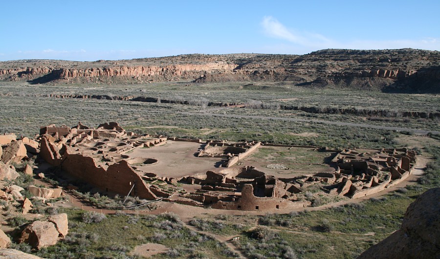
| Pueblo Bonito, a Photo Gallery | D-shaped Pueblo Bonito, possibly five stories tall along the outer arc, has the greatest number of rooms, estimated at 650 rooms, of the Great Pueblos in Chaco Canyon.
|
|
| 2021 ArchaeoBlog | Poverty Point World Heritage Site, National Monument, and State Historic Site
2021.03.14 - I have updated the Poverty Point KML file, Poverty Point Mounds, Maps, and Selected Results, with refined coordinates using LiDAR digital elevation model (DEM) point cloud data to define mound centerpoints or apex coordinates. In the maps folder, the point cloud data is displayed using Excel graphs as image overlays.
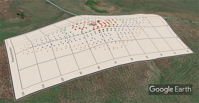
LiDAR DEM Source: Louisiana Statewide GIS Atlas |
|

| The Dresden Codex Lunar Series and Sidereal Astronomy | The Dresden Codex Lunar Series
2009.06.13 - The Dresden Codex Lunar Series presents a span of 11,457 days, equaling 11,292 degrees solar orbit. This amount has a sidereal correspondence with 857 days of lunar orbit motion (Table 1). Also, 11,457 lunar orbits equates to 857 solar orbits and 10,600 lunar synodic periods (moons). And, 857 full moon periods represents a precise integer number of earth rotations:
857.0 full moons
857.0 solar orbits |
= 930.013 lunar nodal
= 11,457.016 lunar orbits |
= 25,377.003 earth rotations
= 10,600.016 full moons |
The "image series" of 11,457 days consists of the nine date intervals between ten images. The full ten intervals span 11,959 days, rather than the 11,960 days more accurately equaling 405 full moons. The 11,959 day interval also has a sidereal correspondence equating solar and lunar orbits. Angular lunar orbit motion during 897 earth rotations equals solar orbit motion during 11,959 days.
| Table 1. Dresden Codex Lunar Series Astronomical Periods. |
| interval (TT) | degrees orbit | lunar periods |
| solar | lunar | synodic | nodal | orbit |
| 11,959 days | 11,786.90 | | 404.9700 | 439.4717 | |
| 897 rotations | | 11,786.92 | | | |
| 857 days | | 11,292.14 | | | |
| 11,457 days | 11,292.12 | | 387.971 | 421.024 | |
| 11,457 lunar orbits | 308,519.6 | 4,124,520.0 | 10,600.001 | 11,503.08 | 11,457.000 |
| 857 solar orbits | 308,520.0 | 4,124,525.3 | 10,600.015 | 11,503.09 | 11,457.015 |
| 857 moons | | 24,943.5 | 857.0 | 930.0128 | |
| 25,377 rotations | 24,943.512 |
| 856.9999 | 930.0129 | |
Apparently, the focus of the lunar series is lunar nodal (the eclipses) and ratios far more accurate than either the Saros or Metonic eclipse periods represent or the eclipse intervals presented in the lunar series. Is sidereal astronomy the reason why the Maya astronomer utilized, instead of the Saros or Metonic eclipse cycles, a lunar series span of 11,457 days equaling 387.97 full moons? The accuracy of the sidereal ratios is very convincing:
| Lunar orbits : moons accuracy | 10,600.0 : 10,600.0012 = 1.0 : 1.000 000 110 |
| Earth rotations : moons accuracy | 25,377.0 : 25,377.0022 = 1.0 : 1.000 000 086 |
The lunar series 11,457 and 11,959 day intervals are apparently based on sidereal astronomy. Is there any question that the Maya were doing sidereal astronomy? Hopefully, this new perspective presents a useful template, the stellar backdrop, upon which to now interpret the Dresden lunar series and other aspects of Native American astronomy.
|
|

| The Àryabhatiya of Àryabhata, the oldest precise astronomical constant? |
2012.08.09 - In 1997, when this research article was accomplished, formulas for astronomy constants were not as refined as today. Now, given new formulations and application of the distinction between atomic and ephemeris time, results will be slightly different. Rather than overwrite this step in examination of ancient astronomy, I'm leaving the article intact with the caveat that researchers should utilize the latest methods to examine the questions raised herein and should expect new results to vary only slightly.
2000.12.31 - Àryabhata wrote that 1,582,237,500 rotations of the Earth equal 57,753,336 lunar orbits. (These same two numbers are also presented by G. R. Kay in his appendices, where they are attributed to Àryabhata and Pusíla.) This is an extremely accurate ratio for two fundamental cosmic motions (1,582,237,500 / 57,753,336 = 27.3964693572) ...
2009.12.21 - I recently found a more accurate ratio expressed by Aristarchus' "Great Year" when interpreted as 4,876 solar orbits. While comparing accuracy I noted Kay's Àryabhata interval, 57,753,339 lunar orbits (rather than Clarke's 57,753,336), precisely equates to a integer of 4,320,027.0 orbits. The solar orbits to lunar orbits ratio is a more precise ratio than Àryabhata's ratio of rotations to lunar orbit.
Since this article posted in 1997, "Kay notes 57,753,339 lunar orbits" has gone unnoticed as a solar orbit integer, as a clue to the more accurate constant. Given Kay's lunar orbits interpretation is a precise integer of solar orbits and an even more accurate second "great ratio" Kay's number has support as an intended interval, likely with 4,320,027 solar orbits.
|
|
| Precise Maya Astronomical Knowledge at Xultun | 2012.06.12 - New evidence implies Maya astronomers possessed precise astronomy as early as 800 C.E. Given the arrangement of older monuments it seemed such must be the case, albeit written evidence was lacking. I just noticed new evidence via a Science article. In May, William A. Saturno, David Stuart, Anthony F. Aveni, and Franco Rossi reported the astronomical tables found in an excavated room in Xutlun, Guatemala, "Many of these hieroglyphs are calendrical in nature and relate astronomical computations..." One numerical array presents several large numbers that imply precise astronomical constants.
... 2012.08.12 - The ancient Maya certainly knew enough to not only teach me a lot about astronomy and time, but also to reveal errors in modern astronomy formulas and bugs in my programming (I hope those are now both in good repair, but I remain vigilant). They certainly forced me to once again correct errors and to refine my research methods with greater precision, this time with an ephemeris perspective sufficient to deal with their day numbers in their time frame and sufficient for the long spans of time represented in their mathematics. For that, I thank them.
Given one current correlation of the Maya calendar with the Roman calendar prevailing today, the Maya Baktun 13 cycle ends on winter solstice, 2012. Knowing what we know about the day and how length of day and year changes with time, this is a predictive feat requiring accurate astronomical knowledge, knowledge which at a minimum must have been held when the calendar was created and the count of days began. ....
|
|

| Ancient Astronomy, Integers, Great Ratios, and Aristarchus | ... Given the logic of geometry, the ... less-nineteen node is the nineteenth solar orbit, when 254.0062 lunar orbits equals (254.0062 less 19.0) lunar synodic periods (254.0062 : 235.0062). Only when 19 solar orbits complete are there 19 more lunar orbits than moons. Eclipse of the 235th lunar synodic occurs just before 254 lunar orbits, revealing that less than 19 orbits equals 235 moons.
The sequence above solves astronomy constants, plus rate of precession is revealed by the orbit-year dichotomy. Eclipses allow timing the relative proportions of lunar synodic and lunar orbits. When 254 orbits complete, there are 235.00046 synodic periods, 18.99954 fewer moons, hence only 18.99954 solar orbits have completed during 254 lunar orbits (254 / 18.99954 = 13.36875 lunar orbits). From the tally of rotations in 254 lunar orbits, the value of rotations per orbit also easily computes (6958.70257/18.9995407 = 366.25636) and minus one resolves days per orbit ...
|
|
| 2015 ArchaeoBlog |
White Pyramid - Pyramid of the Sun - El Paraiso
Teotihuacan to White Pyramid arc = earth's circumference / 3.0
Teotihuacan to El Paraiso arc = earth's diameter / 3.0
Arc distances ratio atop the Pyramid of the Sun = 1.0 : 3.14159
... in Xianyang, the capitol of Emperor Qin's newly-unified China, Emperor Wu of Han (156–87 BCE) built Mao Ling, his tomb and the largest pyramid of the Han Dynasty. The Mao Ling Pyramid became known as the White Pyramid when first reported in the West. Built by the largest cities on their respective continents near the same time, the White Pyramid (Mao Ling) and the Pyramid of the Sun are also near the same size. The mean arc distance from Mao Ling (White Pyramid) to the Pyramid of the Sun and the Pyramid of the Moon is one-third the circumference of the earth (120.00030 degrees, within 34 meters of precise).
El Paraiso, earlier than Teotihuacan and a unified China, was once the largest of preceramic monuments in the Americas and the largest expression of organization and labor investment at the time. El Paraíso's radiocarbon dates span from 3790 ± 100 B.P. to 3020 ± 60 B.P. (Quilter 1985). El Paraiso, part of a long sequence of monument complexes along the Andean coast in Peru, was an aceramic site contemporaneous with early ceramic sites. ....
|
|

| 2015 ArchaeoBlog | Emperor Qin and the Golden Mean
... While not as precise as the latitude placements of Chavin (asin 1/6) and Monk's Mound (atan 4/5) ... the Qin monument does overlap two significant latitudes ... At the Qin Shi Huang pyramid, the latitude equals 0.600067 radians and the colatitude to latitude ratio is 1.0 : 0.61816. The two baselines transect the pyramid field north of Xian, passing just north of the Yan Ling Pyramid (yalip, latitude = 0.59996 radians, = 0.61806 colatitude). At the phi baseline, the ratio of distance to the pole and to the equator is one to phi (1.0 : 1.618034 = 0.618034 : 1.0). This equals the ratio at the pole of the distance to the equator and to the baseline, thus the golden mean (φ = 1.6180340).
|
|
| 2025 ArchaeoBlog | 2025.10.18 - After catching up with Amazonia surveys a month ago, now over 1,500 geoglyphs placemarked, and updating online files my attention shifted to North America ... The earthworks are often termed loop roads. I consider "road" interpretative implying a function, so to avoid naming with interpretations I simply call them loops. I considered using geoglyphs, but prefer a distinct classification. I documented several large loops a few years ago and results of their site-to-site relationships motivated finding and placemarking more loops.
I'm using several lidar viewers with different amounts of contrast to display USGS 3D Elevation Program (3DEP) data based on one meter resolution digital elevation modeling, quite a contrast to survey of satellite imagery for Amazonia. I colorize the lidar to better match the landscape and place the lidar imagery in Google Earth as overlay images. Lidar enhances displaying topography of the flat looking satellite imagery. Tilting and rotating the imagery enhances understanding monument placement in the larger landscape and reveals the viewshed of the monuments. So far I've recorded over forty loops in my area of survey coverage, spanning from Grand Gulch on Cedar Mesa to Mesa Verde. To my surprise, I found several loops are even larger than I expected or realized existed, up to 1,200 meters wide.
After finding a 1,000 meter wide loop, I also began researching the archaeology literature and found they are known to specialists in the region. My surprise of the discovery was nonetheless undiminished. In the 1980s I spent a lot of time in the area recording rock art and had passed near the loops often, driving across one many times and likely even walking across the largest one. I expected site-to-site results to be interesting, but even I was surprised once again.
The Southwest Loops KML placemarks include 68 lidar overlays, 46 loop outlines, 45 site placemarks, selected study results, and a readings list. ....
....
|
|
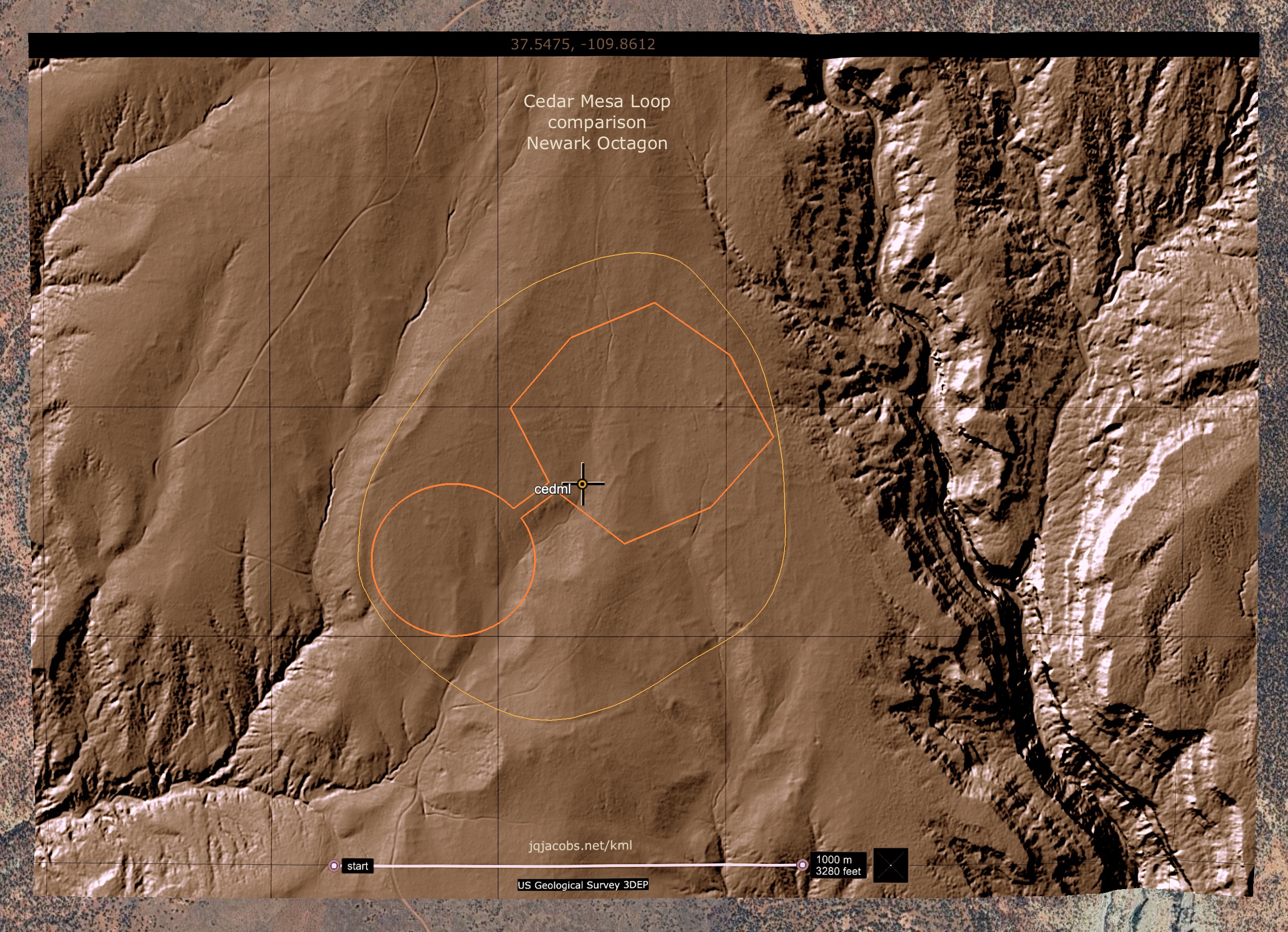
| 2026 ArchaeoBlog | Southwest Loops
Last fall my attention not only shifted to the large earthwork monuments in the Northern San Juan region of the American Southwest, my method shifted from satellite imagery survey to lidar survey. In contrast with survey of satellite imagery in Amazonia, the USGS 3D Elevation Program (3DEP) data based on one meter resolution digital elevation modeling provides high confidence in location precision.
... the ancient southwest loops ... often present as interrupted trails, segmented traces of cleared pathways which originally altered elevation only slightly. Two other factors impact my determinations of their placement in global context, their often irregular forms and the scale of the largest loops. ....
I was surprised finding larger loops than those I'd documented in 2022. Precise results for the first few relationships I checked for the largest loops with major monuments and peaks of the Americas was more expected than surprising. I expected results to include Newark Earthworks but did not expect and was surprised when the results came full circle to my 1991 finding, when I first noted the arc distance between Newark and Marietta earthworks equaled circumference of the earth divided by days per year ....
|
|
| Southwest Loops - KML file. | Determination of the geodetic position of an irregular form not only adds difficulties, the larger the form the likelier the margin of error will be greater. Furthermore, some loops do not evidence continuous forms even with lidar. Unlike the deep ditches of Amazonia geoglyphs, southwest loops are relatively slight modifications of the landscape requiring precise lidar data.
2026.01.07 - The largest loops presented a challenge regarding determination of hypothetical centerpoints ... I decided to test another method. I used Google Earth's Ruler > Path tool to mark equally spaced intervals along the loop outline, then determined the average latitude and longitude of the positions ... I applied the averaging of equidistant positions method to six large, sufficiently continuous loops.
Refining the method of determining the Ute Loop datum (was Ute Circle) reduced the utelo-nccm arc margin of error from sixteen to four meters.
Ute Loop - Eagle Mound - Tumi Chucua Zanja
arcs ratio @ nccm = 2.618039 : 1.0 (-4m)
phi squared = 2.618034

|
|
| Southwest Loops - KML file. |
Grand Gulch Loop - Cedar Mesa Loop - Picket Flat Loop
arcs ratio @ cemel = 1.0 : 0.99970
arcs ratio = 10,796 meters : 10,792 meters
 3000 × 2000 pixels
|
|
©2026 by James Q. Jacobs. All Rights Reserved.
Inquiries welcomed. Contact. |
|
|
|